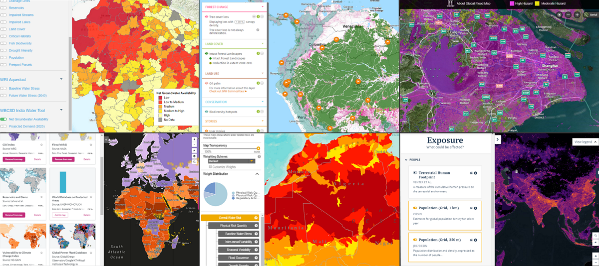
Natural Resource Drivers
Some tools address more than one issue, and will be cross-listed.
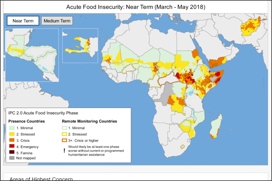
Famine Early Warning System Network (FEWS NET)
USAID, USGS, NOAA, NASA, USDA 1
A near- and medium-term early warning tool with analysis on food insecurity in more than 36 of the world’s most food-insecure countries.
The data are gathered from 22 field offices in collaboration with scientists and NGOs. The goal is to help government decision-makers and relief agencies plan for and respond to humanitarian crises.
Visit the tool here: fews.net
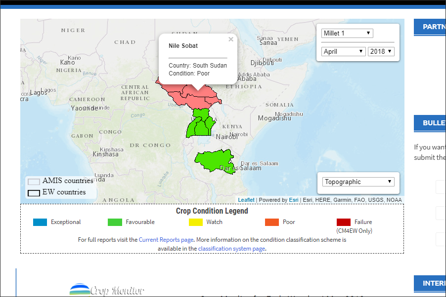
Global Agricultural Geo-monitoring Initiative Crop Monitor (GEOGLAM)
Group on Earth Observations at the World Meteorological Organization2
A crop monitoring tool that collects Earth observations from satellites and integrates them with ground-based and other in-situ measurements.
The goal is to improve market information and transparency in order to make international markets for agricultural commodities more effective.
Visit the tool here: cropmonitor.org
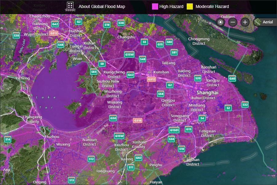
Global Flood Map
FM Global 3
An initial flood assessment tool, based on data and hydrologic models, that identifies areas in high and moderate risk flood zones.
Visit the tool here: www.fmglobal.com/research-and-resources/global-flood-map/flood-map

Global Forest Watch
WRI 4
A global map of forest change data, such as global tree cover, pantropical carbon density, forest fires, boundaries for protected areas, and biodiversity hotspots. WRI utilizes a broad base of local partners, who submit narratives and consume the data.
Although Global Forest Watch could also be considered a research tool, WRI’s stated purpose is to promote transparency about governance of forest resources.
Visit the tool here: www.globalforestwatch.org
Green Infrastructure Support Tool
Earth Genome 5 and World Business Council for Sustainable Development (WBCSD) 6
A decision support tool that enables collaborative consulting based on the Earth Genome platform. It brings together 40+ indicators, scientists, and end-users to identify alternative solutions to water security risks.
Visit the tool here: www.earthgenome.org/gist
Long-Range Energy Alternatives Planning System
Stockholm Environment Institute (SEI) 7
An integrated, medium to long-term scenario-based modeling tool that tracks energy consumption, production, and resource extraction in all sectors of an economy. At least 32 countries used LEAP to create energy and emissions scenarios that were the basis for their Intended Nationally Determined Contributions on Climate Change (NDCs).
Visit the tool here: www.energycommunity.org
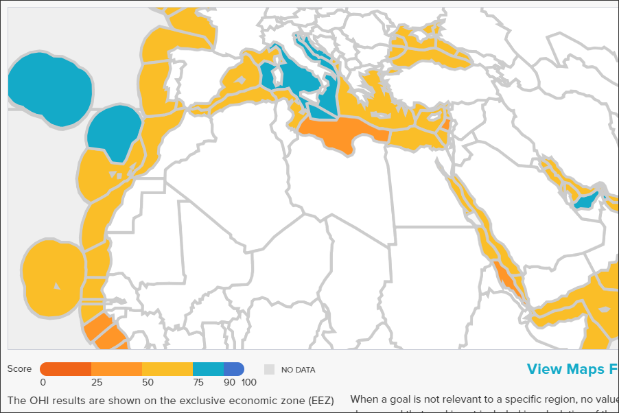
Ocean Health Index
National Center for Ecological Analysis and Synthesis, Sea Around Us, Conservation International, National Geographic, and the New England Aquarium 8
An index that maps the level of achievement of widely accepted socio-ecological goals and scores for 220 countries and territories, Antarctica, and 15 High Seas regions.
There are 10 main goals in the index, including food provision, coastal economies, and coastal protection.
Visit the tool here: www.oceanhealthindex.org
Vital Signs
Conservation International, Wildlife Conservation Society, Africa Innovations Institute, and Tanzania Forest Conservation Group 9
A collection and visualization of standardized data sets and baselines for tracking land degradation across several African countries.
The user can choose different levels of data granularity, ranging from households to global.
Visit the tool here: indicators.vitalsigns.org/map
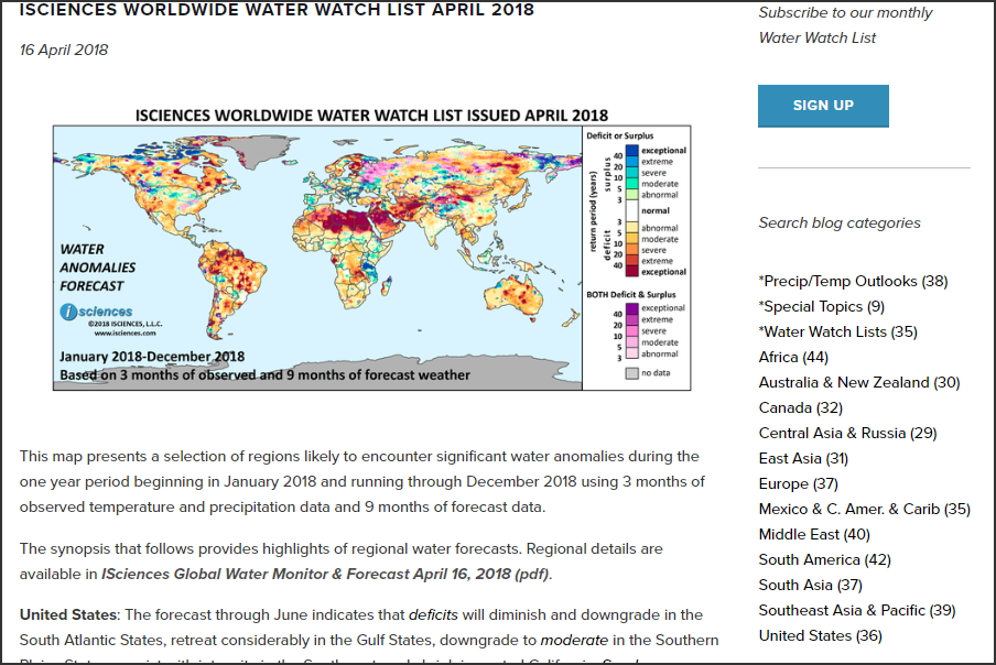
Water Anomalies Forecast
iSciences 10
A monthly PDF report of current water anomalies and future forecasts (up to 9 months).
The underlying water security indicator model identifies regions with significant water anomalies — either deficits or surpluses relative to historically expected quantities using a 1950-2009 baseline period.
Visit the tool here: www.isciences.com
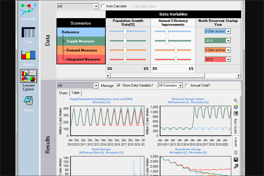
Water Evaluation and Planning System
SEI 11
A software tool for integrated water resources planning that attempts to assist rather than substitute for the skilled planner. WEAP places demand-side issues, such as water use patterns, equipment efficiencies, re-use strategies, costs, and water allocation schemes, on an equal footing with supply-side topics, such as stream flow, groundwater resources, reservoirs, and water transfers.
Visit the tool here: www.weap21.org
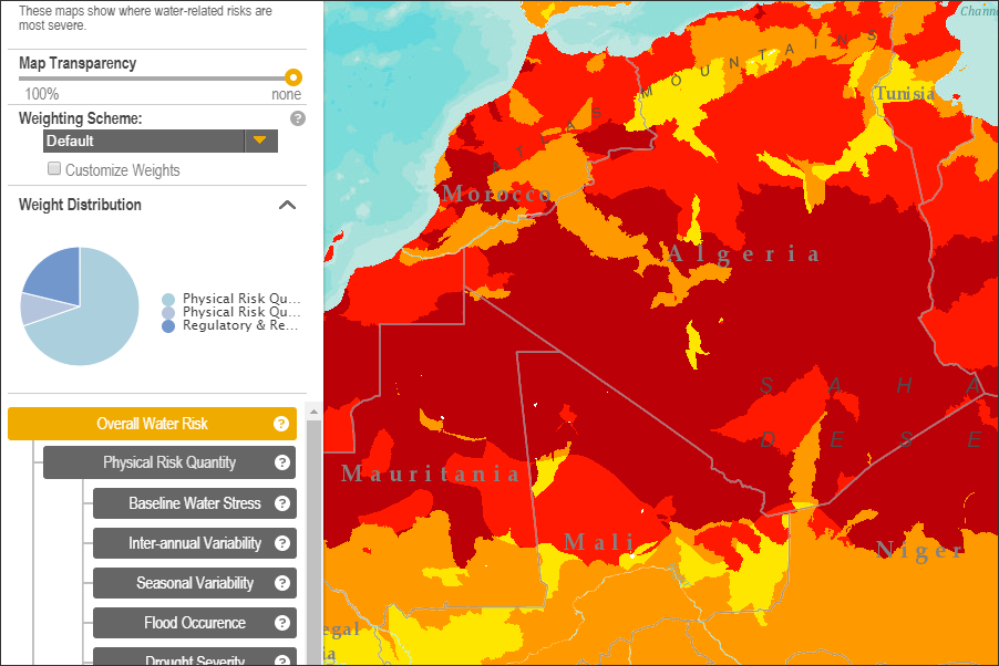
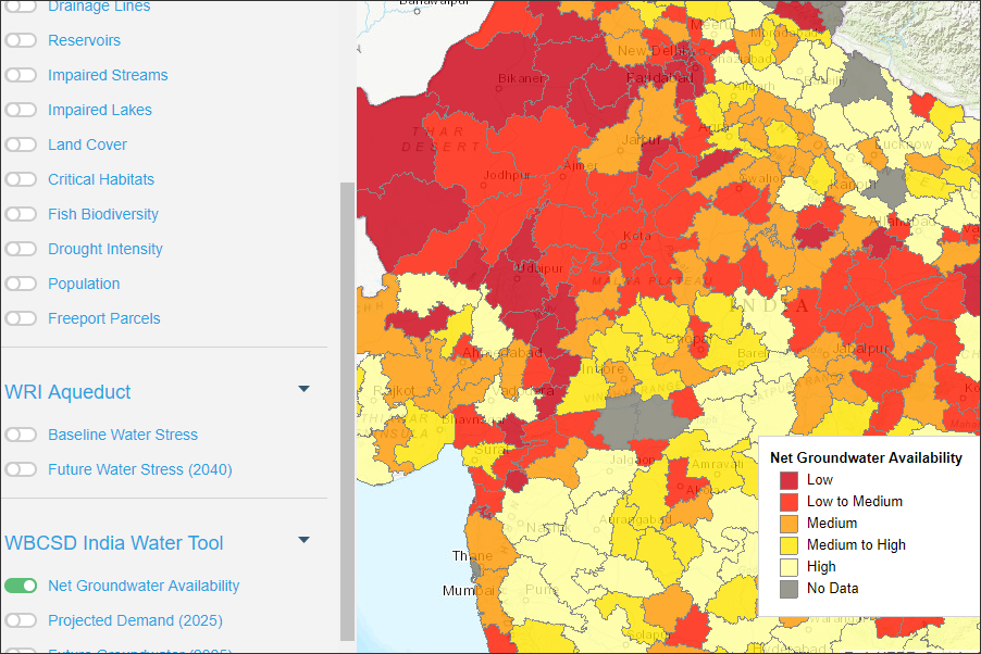
Aqueduct
WRI 12
Maps and indicators that compare current severity of water-related risks across geographies and show how climate change and socio-economic development could affect the availability of and demand for water resources over the coming decades. Users can adjust parameters, including customizing the weight of different indicators and choosing a carbon emission scenario.
Visit the tool here: aqueduct.wri.org

Drivers of Vulnerability Monitor
Hague Center for Strategic Studies (HCSS) 13
A global map that displays 50 security, economic, social, political, and geographic drivers of state vulnerability to intrastate conflict. It also tracks the change in each country’s vulnerability from 1992 to 2014.
Visit the tool here: projects.hcss.nl/monitor/86
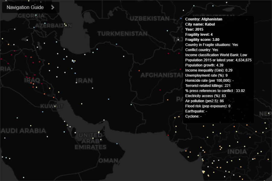
Fragile Cities
Igarape Institute 14 in collaboration with United Nations University, World Economic Forum, and 100 Resilient Cities
A data visualization tool that tracks the distribution and evolution of fragility risk in at least 2,100 cities worldwide since 2000. It features a composite score of city fragility that combines multiple metrics, such as urbanization, inequality, concentrated poverty, youth unemployment, justice deficits, real and perceived insecurity, and natural hazard exposure.
Visit the tool here: fragilecities.igarape.org.br
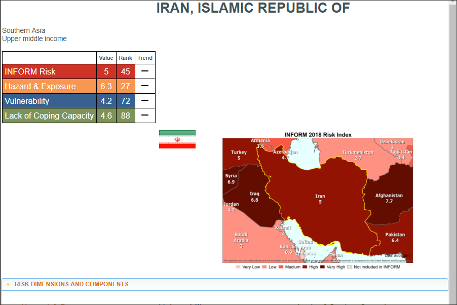
Index for Risk Management (INFORM)
Inter-Agency Standing Committee (IASC) Task Team for Preparedness and Resilience, the European Commission, and others 15
An open-source risk assessment for humanitarian crises and disasters.
The vulnerability rankings are based on 50 indicators across three dimensions of risk: hazards & exposure, vulnerability, and lack of coping capacity.
Visit the tool here: www.inform-index.org

ReliefWeb
UN Office for the Coordination of Humanitarian Affairs (OCHA) 16
The tool curates humanitarian information on global crises and disasters from more than 4,000 vetted sources. It is updated 24/7.
ReliefWeb Labs experiments with ways to improve information-sharing, including mobile apps, APIs, and shared taxonomies.
Visit the tool here: reliefweb.int
Resource Watch
World Resources Institute (WRI) 17
A platform to explore accurate, up-to-date insights about the planet.
Users can create and share visualizations or dashboards using data from satellites, sensors, and social media to tell stories about the state of our planet.
Visit the tool here: resourcewatch.org
Environment, Conflict, & Cooperation Factbook (ECC Factbook)
adelphi 18
An extensive collection of more than 120 detailed, unique factsheets accessible through both a map and a searchable table.
The goal is for users to better understand the drivers behind environmental conflict and cooperation and to harness the lessons learned from earlier (non-) interventions.
Visit the tool here: factbook.ecc-platform.org
Humanitarian Data Exchange (HDX)
UNOCHA 19
An open source platform with two types of data on humanitarian crises and response.
The first type is approximately 130 curated indicators that are comparable across countries. The second type of data includes more than 6,000 data sets contributed by vetted organizations.
Visit the tool here: data.humdata.org
MapX
UN Environment Program, the World Bank, and the Global Resource Information 20
MapX is a decision support tool where stakeholders can build customized applications on a common platform.
The goal is to generate actionable insights from geospatial data to inform dialogue and help all stakeholders understand benefits and risks, manage expectations, and make evidence-based decisions.
Visit the tool here: www.mapx.org

Notre Dame Global Adaptation Initiative (ND-GAIN)
University of Notre Dame 21
A country-level ranking system that captures a country’s vulnerability to climate change and other global challenges , and its readiness to improve resilience. It is updated annually.
Visit the tool here: gain.nd.edu
Partnership for Resilience & Preparedness (PREP)
A map-based, open, online data platform that allows users to access and visualize spatial data on past and future climate, as well as physical and socioeconomic data.
The tool is built on the Resource Watch platform and allows organizations to customize dashboards to align local efforts.
Visit the tool here: www.prepdata.org

World Bank Open Data
The World Bank 24
A curated collection of longitudinal data and profiles of countries, for visualization and download.
The data covers a range of topics, including demographics, environment, economy, states and markets, and global links.
Visit the tool here: data.worldbank.org
Citations
- A USAID-managed, U.S. intergovernmental investment.
- A voluntary partnership of 100+ national governments and 100+ international organizations.
- A U.S.-based property insurance company.
- A U.S.-based independent environmental research organization funded by foundations, government, corporations, and NGOs.
- A private consulting company.
- An independent advocacy group led and supported by member companies.
- A global science policy research organization headquartered in Sweden, funded by the Swedish and other governments, foundations, corporations, and NGOs.
- A collaboration of U.S.-based independent research, advocacy, and educational institutions, diversely funded.
- Independent research and advocacy groups based in the U.S., Uganda, and Tanzania with diverse funding sources.
- A Michigan-based consulting firm.
- A global science policy research organization headquartered in Sweden, funded by the Swedish and other governments, foundations, corporations, and NGOs.
- A U.S.-based independent environmental research organization funded by foundations, government, corporations, and NGOs.
- An independent Netherlands-based research organization, funded by governments, foundations, and NGOs.
- A Brazil-based independent research organization funded by governments, foundations, NGOs, and individuals.
- A UN organization that coordinates among UN and other international humanitarian groups.
- A UN office that mobilizes and coordinates humanitarian assistance.
- A U.S.-based independent environmental research organization funded by foundations, government, corporations, and NGOs.
- A Berlin-based independent research firm focused on environment and development funded by the German government and diverse clients.
- A UN office that mobilizes and coordinates humanitarian assistance.
- A project of international institutions, funded through fee-for-service.
- A private U.S.-based university.
- An international research organization funded by foundations, governments, and universities.
- A U.S.-based independent environmental research organization funded by foundations, government, corporations, and NGOs.
- An international financial institution with 189 member countries.