Climate Change
Some tools address more than one issue, and will be cross-listed.

Climate Impact Map
Climate Impact Lab 1
A straightforward data visualization of global and US climate change projections through the end of the century.
The interface allows users to zoom in to local areas and change the time frame, emissions scenarios, probability and ways to view temperature change (for example, “Number of days greater than 95 deg F.”)
Visit the tool here: www.impactlab.org/map

Climate Watch: Data for Climate Actions
WRI 2 and the NDC Partnership 3
A clearinghouse for dozens of datasets to compare Nationally Determined Contributions (NDCs) under the Paris Agreement, historical emissions data, emissions scenario pathways, and relevant sustainable development goals.
Visit the tool here: www.climatewatchdata.org
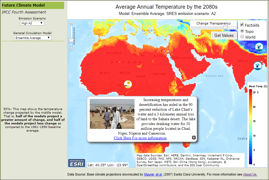
Climate Wizard
The Nature Conservancy, University of Washington, and University of Southern Mississippi 4
This tool maps historic and future predictions of temperature and rainfall around the world, with options to compare and view different predictive models and greenhouse gas emission scenarios.
Visit the tool here: www.climatewizard.org
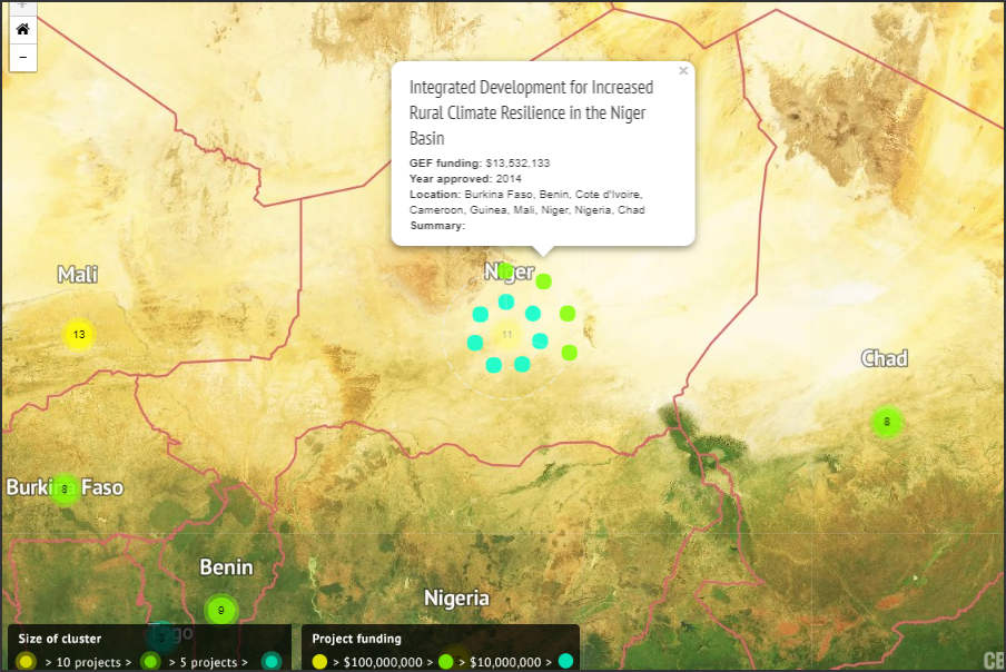
Mapped: Where multilateral climate funds spend their money
Carbon Brief 5
A map profiling more than 1,000 projects funded from 2009-2017 by the four main multilateral climate funds.
The map includes: the Green Climate Fund (GCF); Adaptation Fund; Climate Investment Funds (CIF); and Global Environment Facility (GEF).
Visit the tool here: www.carbonbrief.org/mapped-where-multilateral-climate-funds-spend-their-money
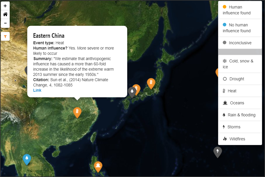
Mapped: Attributing extreme weather to climate change
Carbon Brief6
A geographic display of locations where peer-reviewed studies attribute extreme weather events to climate change.
Visit the tool here: www.carbonbrief.org/mapped-how-climate-change-affects-extreme-weather-around-the-world
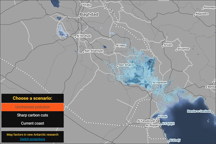
Surging Seas
Climate Central 7
A visualization of local projected sea levels for the year 2100 under different carbon pollution scenarios.
The projections are based on peer-reviewed research, and include data on how many people will potentially be living on land that could be affected in the future.
Visit the tool here: sealevel.climatecentral.org
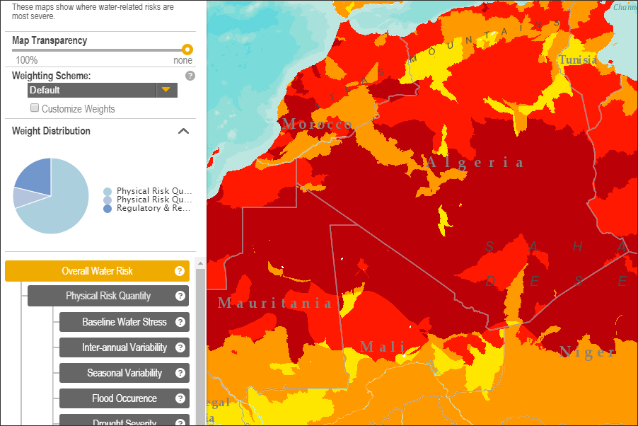
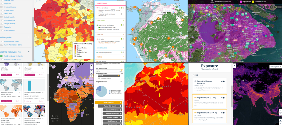
Aqueduct
WRI 8
Maps and indicators that compare current severity of water-related risks across geographies and show how climate change and socio-economic development could affect the availability of and demand for water resources over the coming decades. Users can adjust parameters, including customizing the weight of different indicators and choosing a carbon emission scenario.
Visit the tool here: aqueduct.wri.org
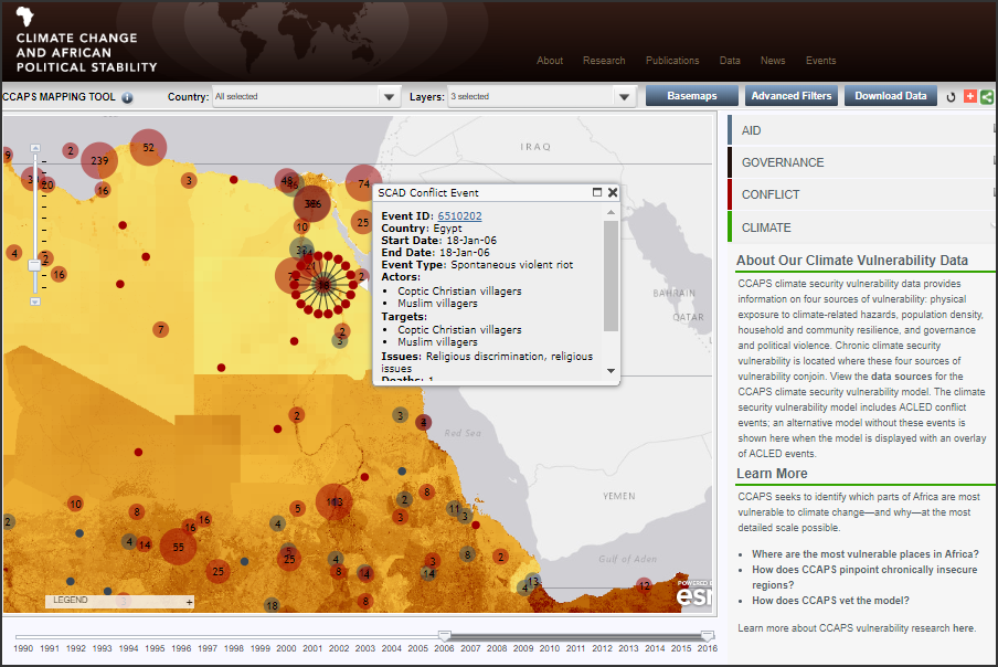
Climate Change and African Political Stability (CCAPS)
Strauss Center at the University of Texas at Austin 9
A mapped display of information on four sources of vulnerability across Africa: physical exposure to climate-related hazards, population density, household and community resilience, and governance and political violence.
The data represented is from 2006 to 2016.
Visit the tool here: ccaps.developmentgateway.org
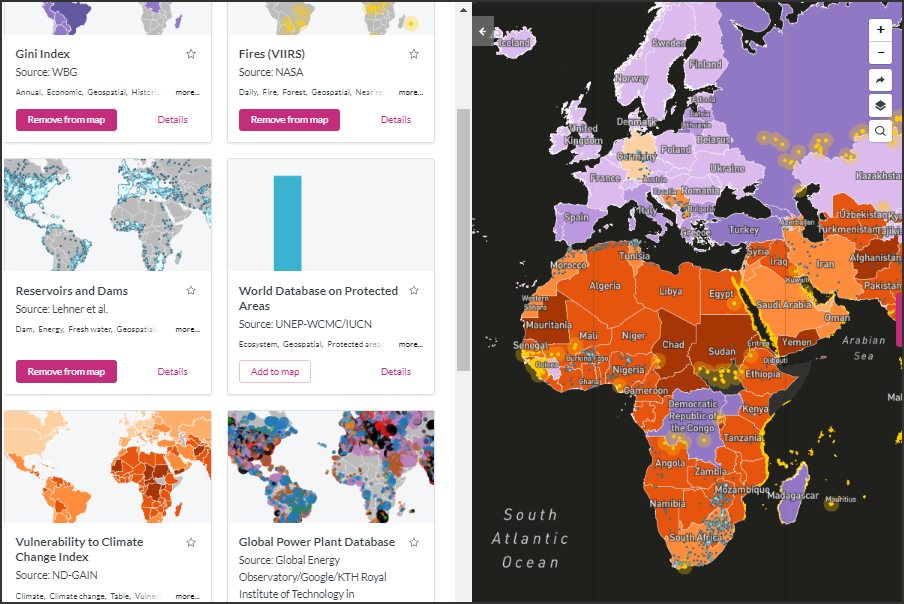
Resource Watch
World Resources Institute (WRI) 10
A platform to explore accurate, up-to-date insights about the planet.
Users can create and share visualizations or dashboards using data from satellites, sensors, and social media to tell stories about the state of our planet.
Visit the tool here: resourcewatch.org
Environment, Conflict, & Cooperation Factbook (ECC Factbook)
adelphi 11
An extensive collection of more than 120 detailed, unique factsheets accessible through both a map and a searchable table.
The goal is for users to better understand the drivers behind environmental conflict and cooperation and to harness the lessons learned from earlier (non-) interventions.
Visit the tool here: factbook.ecc-platform.org
Humanitarian Data Exchange (HDX)
UNOCHA 12
An open source platform with two types of data on humanitarian crises and response.
The first type is approximately 130 curated indicators that are comparable across countries. The second type of data includes more than 6,000 data sets contributed by vetted organizations.
Visit the tool here: data.humdata.org
MapX
UN Environment Program, the World Bank, and the Global Resource Information 13
MapX is a decision support tool where stakeholders can build customized applications on a common platform.
The goal is to generate actionable insights from geospatial data to inform dialogue and help all stakeholders understand benefits and risks, manage expectations, and make evidence-based decisions.
Visit the tool here: www.mapx.org

Notre Dame Global Adaptation Initiative (ND-GAIN)
University of Notre Dame 14
A country-level ranking system that captures a country’s vulnerability to climate change and other global challenges , and its readiness to improve resilience. It is updated annually.
Visit the tool here: gain.nd.edu
Partnership for Resilience & Preparedness (PREP)
A map-based, open, online data platform that allows users to access and visualize spatial data on past and future climate, as well as physical and socioeconomic data.
The tool is built on the Resource Watch platform and allows organizations to customize dashboards to align local efforts.
Visit the tool here: www.prepdata.org

World Bank Open Data
The World Bank 17
A curated collection of longitudinal data and profiles of countries, for visualization and download.
The data covers a range of topics, including demographics, environment, economy, states and markets, and global links.
Visit the tool here: data.worldbank.org
Citations
- A U.S.-based independent environmental research organization funded by foundations, governments, corporations, and NGOs.
- A U.S.-based independent environmental research organization funded by foundations, government, corporations, and NGOs.
- A global coalition of countries and international organizations devoted to advancing the NDCs and SDGs with a climate focus.
- A collaborative effort between an independent environmental advocacy group (funded by individuals and governments) and two public U.S. universities.
- A U.K.-based news site focused on energy policy and climate science funded by foundations.
- A U.K.-based news site focused on energy policy and climate science funded by foundations.
- An independent, U.S.-based research organization focused on climate science, funded by foundations and governments.
- A U.S.-based independent environmental research organization funded by foundations, government, corporations, and NGOs.
- A public university research collaboration funded by the U.S. Department of Defense.
- A U.S.-based independent environmental research organization funded by foundations, government, corporations, and NGOs.
- A Berlin-based independent research firm focused on environment and development funded by the German government and diverse clients.
- A UN office that mobilizes and coordinates humanitarian assistance.
- A project of international institutions, funded through fee-for-service.
- A private U.S.-based university.
- An international research organization funded by foundations, governments, and universities.
- A U.S.-based independent environmental research organization funded by foundations, government, corporations, and NGOs.
- An international financial institution with 189 member countries.