Table of Contents
Other Cases, Other Places
In our consultations with target users of the conflict forecast tool, we heard a number of potential uses. Ultimately, actual project planning requires local context, and even the best curated datasets cannot replace on-the-ground knowledge. The tool can nevertheless be used to communicate to senior leaders where risk is high or growing, and it offers a possible way to prioritize conflict prevention or recovery investments.
In particular, the New America Phase Zero team is interested in how a tool like this may be useful to military organizations in understanding nonmilitary aspects of security situations. Even if water-based solutions are outside the scope of action for militaries, the underlying water-based problems are very much a relevant part of the security landscape. We hope this tool can help demonstrate the relevance with rigorous, quantitative information, and also offer a means to produce more comprehensive security assessments than are currently available to most military and civilian organizations.
In the case of Ethiopia and Somali region, the conflict prediction tool highlighted high conflict risk, as well as some of the underlying drivers of that risk, including water stress. The U.S. government has identified Ethiopia as a strategically significant country and an important regional partner. The stability of Ethiopia is important not just to its own residents, but to the region, the continent, and the world. In turn, Somali region is crucial for maintaining stability within Ethiopia, given its proximity to conflict-torn Somalia, as well as conflict hotspots within Ethiopia. Understanding the nature and magnitude of risk in the area, as well as how to reduce it, is important for promoting national security interests for Ethiopia and for the United States—even if the actual prescription might be investment in improved water management.
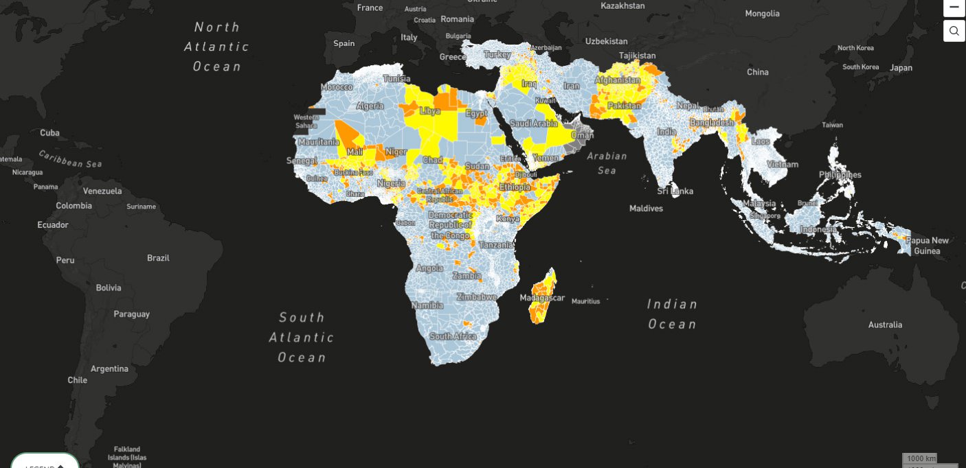
The conflict prediction map can provide such insights for other countries where the United States has strategic interests or military operations. Niger and the Philippines are illustrative of the possibilities, and also the differences in how this map may provide insights for different geographic contexts.
Niger, which sits west of Ethiopia in Sahelian Africa, is an important partner to the United States. According to U.S. Africa Command,1 American and Nigerien "militaries have been stalwart allies focused on working together to deter and to defeat terrorist threats in the West African nation and across the Sahel region." The U.S. Department of Defense has a significant presence in the region, including a military base2 near Agadez. While the focus of the American military presence is counterterrorism missions across the region, the United States also has an interest and investment in stabilization and support3 for the host nation of Niger. The conflict forecast tool may not provide the sort of localized data and context necessary for operational or campaign planning, but it can help illuminate the patterns of risk, centers of instability and reasons for it. The tool may help guide the effectiveness of stability investments in the country.
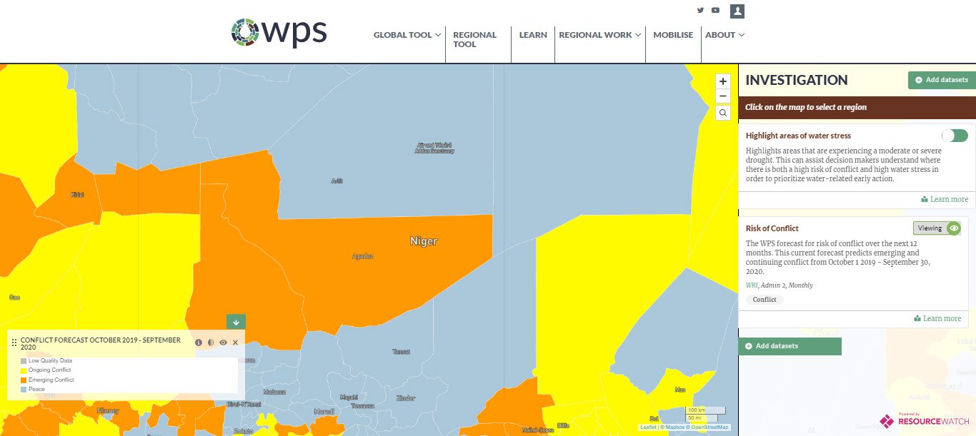
The forecast for Niger is not especially encouraging, with most of the country considered likely to experience conflict, whether new or ongoing. And as shown in the full forecast dataset available for download, in most of the relatively populous southwest especially, the conflict risk is especially high.
The recent ACLED history further highlights the extremely low population density in much of Niger. Closely related is the accessibility of various parts of the country. ACLED events are strikingly correlated with the transportation network, as illustrated by maps showing travel time to the nearest city, although this may in part be an artifact of reporting.
In assessing what is behind the forecasted high risk of conflict, it is worth noting that the Sahel is a famously dry region. Yet precipitation data indicate that conditions have been normal or a bit wetter than usual, and indeed, that description holds for much of the past decade across the entire country. Baseline water stress is high in only a couple of areas, which do not overlap with population centers.
Water supply may not be a driving factor, but the tool allows us to look elsewhere. Nationally, the portion of Niger’s population with access to an improved source of drinking water is lower than in any neighboring countries, with the exception of Chad. The story is the same for access to sanitation facilities, as well as to electricity. Although these could be called development indicators, they also can serve as a proxy for the presence of the state and its capacity to provide services and basic infrastructure for its citizens. It is notable that Niger scores acceptably on a range of governance metrics, including perceptions of corruption and the rule of law.
In other places, the tool tells a different story. The Philippines, for example, is an important partner for the United States of long-standing strategic significance. That interest intensified in the wake of America's "rebalance" to Asia and the strategic competition between the United States and China, which was explicitly recognized in the 2017 National Security Strategy and 2018 National Defense Strategy. Accordingly, actual or potential conflict in the Philippines is a topic of direct strategic interest to the United States—and one that can be explored using our tool.
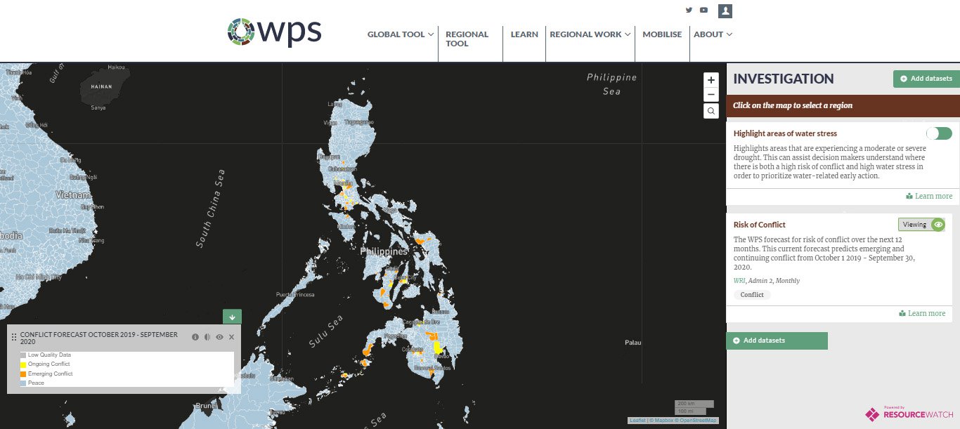
Unsurprisingly, given the violent unrest on some islands in recent years—in some cases rising to the level of insurrection—the model forecasts ongoing as well as emerging conflict in many, though far from most, districts in the Philippines, including several population centers. In this way, the forecast is not totally unlike those for Ethiopia and Niger. Using the tool to look a bit deeper, though, reveals a very different story. This outcome is not totally unlike the forecast in Ethiopia or Niger. Using the tool to look a bit deeper, though, reveals a very different story. Baseline water stress in the Philippines is low for most of the country. Seasonal water supply variability is similarly low, and even interannual variability is moderate. Riverine flood risk, meanwhile, is exceptionally high. But this represents a very different type of challenge to locals and government bodies. In general, the Philippines does not appear to be water-stressed.
High conflict risk in the absence of high water stress serves to highlight the fact that the model tries to predict conflict risk, not the risk of conflict due to water. Although water is often omitted from discussions and analyses of conflict among traditional national security analysts, and our research attempts to redress that oversight, this does not imply that water plays a significant role in every conflict. Completely different factors—among them political, economic, and ethnic—may drive conflict. Although the tool itself emphasizes water, it also allows users to explore other factors. In the Philippines, recent conflict history is obviously germane to the prospects of future conflict; the density of events and, in particular, the frequency of violence against civilians would seemingly augur poorly for peace.