Abstract
Early action requires early warning. Nations and non-governmental organizations alike have long sought the means to anticipate conflict in hopes of preventing violence or mitigating damage. Data analysis techniques, such as mathematical modeling and machine learning, offer new opportunities for forecasting the incidence of organized violence based on underlying conditions, including by using variables that are often absent from more traditional predictions, such as water stress. In December 2019, the Water, Peace, and Security partnership, a group of research organizations sponsored by the Government of the Netherlands, launched a new conflict prediction model using these advanced techniques. This case study peels back the curtain to show how the research team built the model, how decision makers might use such a tool, and observations from a "ground truthing" trip the team took to an area in Ethiopia identified by the model as at high risk for conflict.
Acknowledgments
Peter Kerins is the principal author of this report, with input from Sharon Burke. Peter is also a lead designer of the conflict prediction tool, along with Liz Saccoccia and Samantha Kuzma of the World Resources Institute. Peter and Sharon were part of the research team that visited Ethiopia, along with Liz Saccoccia and Rachel Zimmerman, who was then with New America, both of whom provided valuable insights and feedback. Liz also commented on early drafts of this report. We're grateful to WRI's Charlie Iceland for his leadership of the conflict prediction model, and Susanne Schmeier, who so ably steers the entire Water, Peace, and Security Partnership. Mercy Corps in both Addis Ababa and Jigjiga were generous with their expertise and advice, and we not only appreciated their help with our research, but the important and inspiring work they do there every day. Finally, the authors would like to thank Alison Yost, New America's Director of Communications, and Joe Wilkes, New America's Media Relations Assistant, for their hard work in producing this case study.
Introduction
Early action requires early warning. Nations and non-governmental organizations alike have long looked for ways to anticipate conflict far enough in advance to prevent or mitigate it. The field of conflict studies has made major progress toward that kind of foresight by cataloguing, analyzing, and in some cases modeling conflict events. However, this work is often limited in geographic scope, difficult to generalize (due to theoretical or practical constraints, such as data availability), or focused on a narrow range of drivers or outcomes.
The Water, Peace and Security (WPS) partnership, a public-private collaboration sponsored by the government of the Netherlands with additional support from the Skoll Foundation, has developed a model for forecasting lethal conflict—defined here as organized political violence1—that overcomes some of the constraints. By gathering, processing, and harmonizing dozens of quantitative indicators, we created a single dataset that describes local conditions around the globe since the early 2000s. We then applied machine learning to these data to create a quantitative model that warns of conflict risk up to a year in advance.
Our work differs from existing research in a number of ways. First, it is global in scope. Second, the model makes predictions at a fairly high resolution: the second-level administrative district (equivalent to a county in most of the United States). Third, it incorporates indicators from a wide variety of domains, such as economics, demography, and health. Fourth, these inputs include novel remote sensing-based datasets that help capture the biophysical environment and its possible influence on conflict. These environmental factors, particularly water, were a point of emphasis for our research. Finally, the machine learning approach (described in detail below) means that our findings are largely uncolored by a priori assumptions. Instead, the data speak for themselves.
All of this work—not just the conflict forecasts, but also the underlying datasets and the model itself—now resides in an open-source, web-based platform, designed as a decision support tool for actors in conflict prevention, defense, diplomacy, development, humanitarian relief, and related research areas. The goals of the tool are twofold: first, to identify where the risk of conflict is high or rising, and second, to provide some insights into why the risk is high or rising. Different audiences may use the tool to investigate different questions, but its core function is to provide useful, accurate information about the location, nature, and possible drivers of potential conflicts. Although both the model and the underlying data have limitations, the tool presents a big-picture overview of emerging security situations within a coherent and consistent framework.
Furthermore, beyond the model itself, the tool provides a vehicle for the easy exploration of local or regional conditions. By examining current events and conditions alongside historical time series, users can investigate a given area and draw their own conclusions about the security situation and the pertinent factors for conflict or peace. Users can combine their own expertise and local knowledge with rigorously processed datasets to distill insights, identify new connections, or illustrate experiential or anecdotal knowledge with high-quality quantitative data.
Citations
- Adopted from ACLED, described below. source
How the Model Works
As noted, the Water, Peace and Security research team collected and reconciled a large number of indicator datasets across a wide range of topics, all reaching back to at least the early 2000s. For every month in each administrative district, we paired indicator values at that place and time with the absence or presence of conflict events over the following year, as recorded in ACLED: the Armed Conflict Location Event Database.1 In this way, the data explicitly link conditions with outcomes.
We then used these samples—each corresponding to a single month in a single district—to train predictive models, in a process known as supervised machine learning.2 In such a process, a model "learns" from training samples by comparing its predictions with actual outcomes and then adjusting itself slightly whenever a prediction is wrong. With enough samples and iterations, the model can come to recognize and replicate the underlying patterns between inputs and outputs. A successful model can then make useful predictions, such as forecasting future outcomes based on present conditions, where only the input values are known.
A key step was selecting which of the available datasets to actually utilize for making predictions because, for both technical and practical reasons, using all of the available indicators was undesirable. But since a guiding philosophy of the project was to let the data speak for themselves, we did not want to simply impute importance to certain selected indicators. Accordingly, we used a strictly quantitative process known as recursive feature elimination3 to identify the datasets that were most effective for predicting the absence or presence of conflict, without any regard for or knowledge of which datasets represented which indicators or what societal dynamics.
The results support the notion that conflict is linked to a broad range of factors and dynamics. There is wide acknowledgement that a history of conflict in an area is strongly correlated with conflict in the future, but much weaker consensus beyond that. The impact of factors like agricultural practices or population distribution and, most saliently for this project, the role of water have not been adequately investigated. Our algorithm identified several water-related indicators as highly predictive of conflict (though note that our research is looking only at correlation, not causation).
The tool provides the opportunity to explore the full range of datasets and topics, independently or in combination, in conjunction with both model predictions and historical conflict events. The select inputs to the model are available, as well as all of the quantitative indicators and various contextual geospatial datasets, from roadways to surface reservoirs.
Citations
- Clionadh Raleigh, Andrew Linke, Håvard Hegre, and Joakim Karlsen, “Introducing ACLED-Armed Conflict Location and Event Data,” Journal of Peace Research 47, no. 5 (2010): 651–60. All data, as well as extensive documentation, are publicly available at source.
- For a simple description of supervised machine learning and how it differs from other types of machine learning, see source.
- To learn a bit more about recursive feature elimination, see source. Note that we did not utilize cross-validation because of the time series-like nature of the data.
Testing the Tool
On-the-ground experience and expertise rooted in a particular time and place can best characterize the pathways that lead toward—or away from—violent conflict. The purpose of the tool is to open a window onto these causal paths and allow a user to inspect, measure, and systematically investigate the relevant factors, including those that are strongly correlated with conflict outcomes but are frequently ignored.
This case study is meant to demonstrate that cycle and show how the tool can provide quick and easy access to meaningful data about the dynamics that local experts identify as critically important to conflict. In this way the tool supports decision-making by defense, development, diplomacy, and humanitarian actors considering how to prevent or manage instability, unrest, or conflict in a given area.
We traveled to Ethiopia in May 2019 to test this vision of the tool's utility. Applying our research in a specific place allowed us to evaluate the tool's capabilities and shortcomings in the context of real local conditions and needs, and incorporate potential users’ detailed feedback into the design of the tool. Furthermore, speaking with locals yielded valuable insights about our conceptual framework and the ability of the model to capture the causal dynamics at play in the real world. In the case of Ethiopia, these local conditions and concerns frequently revolve around water.
Ethiopia
All people and all countries need water, but Ethiopia faces a particular challenge, in a number of ways. For one, the country is critically dependent on rivers—ultimately, rain—for electricity. Taking advantage of its robust topography, Ethiopia's power generation capacity is more than 90 percent of hydropower.1 Throughout the spring of 2019, including during our research visit, the government had to institute power rationing due to low water levels in key dams and mechanical difficulties in others.2 Beyond the direct challenges of rolling blackouts, the economic effects were substantial, with major impacts on domestic industry as well as the suspension of electricity exports to neighboring countries.3,4 Despite the concentration of risk, the government plans to bring much more hydropower capacity online in the years to come, through a national project already well underway. This includes the Grand Ethiopian Renaissance Dam, a project that itself has the potential to spark conflict with Egypt, Ethiopia’s downstream neighbor.5
Ethiopia’s agricultural sector is also enormously dependent on rainfall. Only a small fraction of the country's arable land is irrigated, although that is increasing.6,7 Furthermore, Ethiopia is relatively reliant on food grown within its own borders, rather than imports, so when crops fail, prices can spike dramatically.8 The connection between shortages of staple foodstuffs and civil unrest is well documented.
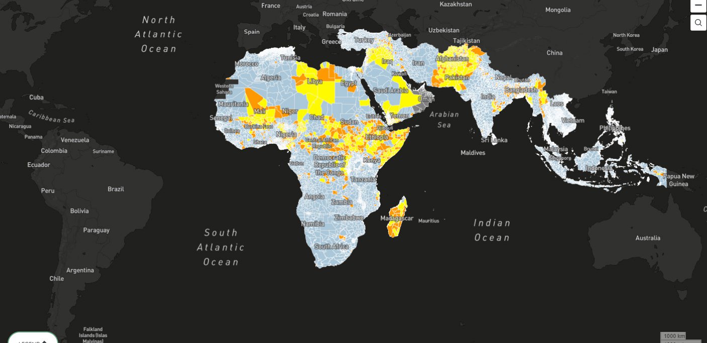
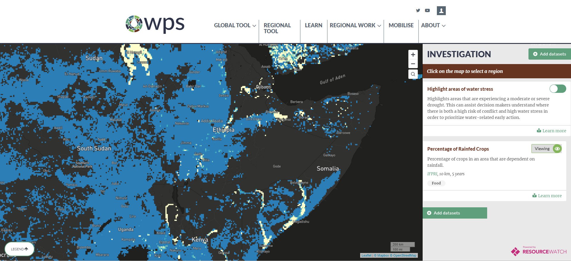
The forecast map appears to show, for example, a significant overlap between the presence of rainfed agriculture and conflict, whether ongoing or emerging. Could the relationship really be so simple, or is this mere coincidence? The answer is, of course, neither. Historically speaking, the presence of rain-fed agriculture is correlated with conflict—but so are many other factors. Forecasted conflict also corresponds pretty neatly with, for example, population density—another relevant but nondeterminative factor. Trying to understand the nature and origins of conflict in a particular place requires a closer look. (The results presented in this case study represent a forecast made at the end of 2018 and covering all of 2019.)
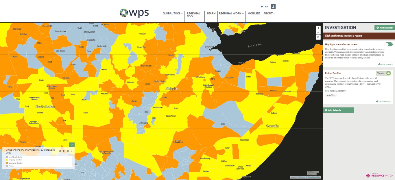
The map appears to show a significant correspondence between the presence of rain-fed agriculture and an elevated risk of conflict. Is the relationship really so simple, or is this overlap mere coincidence? The answer is, of course, neither. Historically speaking, the presence of rain-fed agriculture is correlated with conflict—but so are many other factors. The conflict risk forecast also corresponds pretty neatly with, for example, population density—another relevant but nondeterminative factor. Trying to understand the nature and origins of conflict in a particular place requires a closer look.
Somali Regional State
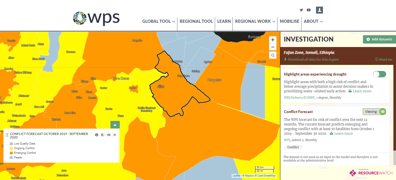
One hotspot visible in the national forecast centers around a pair of zones (second-level administrative units) in the eastern part of Ethiopia: Fafan, where the model forecasts the emergence of conflict, and Misraq Harerge, where existing conflict is forecast to continue. Downloading the full forecast dataset from the tool reveals that the ascribed risk of conflict in these zones is as high as anywhere in the entire country. Perhaps not coincidentally, both zones are centers of distinct populations at the interface between the Somali and Oromia regions (the first-level administrative units in the country). Sitting in the easternmost part of Ethiopia, Somali region's population is predominantly ethnically Somali and religiously Muslim, according to the latest available census data from 2007.1 Oromia covers much of the center of Ethiopia and is majority Oromo, with roughly equal populations of Muslims and Christians of various denominations.2
Understanding the recent conflict history of an area is a prerequisite for evaluating the prospects for future conflict, but that information may not always be easily accessible, comprehensive, or navigable. Because ACLED is a unified, global register of conflict-related events, the model is able to utilize ACLED, and the tool allows users to explore that history with ease. Users can inspect the essential details of individual events, such as battles, protests, or riots: where and when they took place, who participated, and how many people died. At the aggregate, district level, charts show the rate of incidence of different types of events over time.
In Fafan zone, some events seem to be clearly contingent on temporary political circumstances. For example, many of the 2018 events were demonstrations against the regional governor at the time, who stands accused by international groups of extensive human rights violations and is currently jailed on charges of inciting violence.3 Other events were police violence against those protesters.4 However, looking at a longer arc of events, water appears to be a common denominator and crucial element—a notion local actors confirmed to the WPS research team.
ACLED has its limitations. It spans less than two decades and is manually curated, so it has fewer entries than comparable conflict databases that are machine-coded. Such automation, however, introduces major challenges of fidelity. After a lengthy assessment of all available conflict datasets, the team selected ACLED for a number of reasons, above all the superior quality of its entries.
Citations
- source
- source
- Associated Press, Reuters, "Ethiopian Somali Region Ex-President Abdi Mohammed Omar Arrested After Prisoners Intimidated by Lions, Hyenas," August 28, 2018. source; The Economist, "Ethiopia's Most Repressive State Is Reforming," October 5, 2019. source
- James Moody, Ethiopia: Protests Shift from Oromia to Somali Province, ACLED, May 5, 2018. source
Basic Water Usage (Jigjiga City)
In May 2019, members of WPS from the World Resources Institute traveled to Somali regional state in Ethiopia, along with partners from New America's Phase Zero project. With the help of a locally staffed charity, we sought to compare our conceptual framework with the ground truth of a place to which our model ascribed very high conflict risk. We also met with potential users of our tool from local and national governments as well as international organizations to solicit feedback on how they might make use of the tool.
We started our visit in Jigjiga, the capital of Somali region and the 10th-largest city in the country. Its roads were a whirl of trucks, cars, three-wheeled taxis, camels, and donkeys, its sidewalks packed with vendors, shoeshiners, plastic outdoor furniture, buskers, beggars, stalls, goats, and more. The strange juxtapositions of rapid development abounded: rough livestock pens built of unfinished stakes abutting small strip malls boasting hair transplant centers; the skyline of a construction boom along streets dotted with destitute women and children we were told were refugees.
In an interview at his office, Bashir Hasan Adal of the Regional Water Resource Development Bureau in Jigjiga was unambiguous about the role of water in the area: "Ultimately, water is the number one issue for communities. … In the Somali [region], the top priority is groundwater." There is large geological variation across the region when it comes to water, in terms of both availability and quality. Water levels, he continued, "can be a friction point interethnically, depending on the distribution in space [of water and infrastructure]." As for the consequences, "In border areas, when there is drought, people will fight to gain access to water resources by force."
The situation Adal described is not hypothetical. As noted by Mohamed Nur Isse, regional deputy head of the Disaster Prevention and Preparedness Bureau, Somali region contains hundreds of thousands of internally displaced persons1 "due to drought and lack of rainfall." As a whole, Ethiopia has an additional 3 million internally displaced persons due to domestic unrest—the highest national tally in the world.2 Additionally, Jigjiga alone hosts tens of thousands of refugees from the neighboring nation of Somalia.3 Internally displaced persons are typically eager to go back home, Isse noted, but those who are displaced because of conflict are not willing to return, despite the poor living conditions and social destabilization of the refugee camps, due to ongoing concerns for their safety.4
Among the local actors we interviewed, the importance of water to conflict was self-evident and uncontested: any understanding of local conflict drivers is incomplete without awareness of local water dynamics. More complicated is how someone outside the area can begin to understand these dynamics, as well as how someone who already knows something about these dynamics would quantify or communicate that information.
Technical, empirical means are one way to answer questions about the role of water in local conflict. For starters, researchers have developed spatially precise indicators that capture the water characteristics of an area. For example, baseline water stress represents "the ratio of total withdrawals to total renewable supply in a given area."5 The Water, Peace and Security model incorporates several such indicators,6 which have a measurable impact on its forecasts. The tool presents all of these in a simple visual format that allows any user to examine an area's fundamental exposure to water challenges.
Citations
- Internal Displacement Monitoring Centre, "Ethiopia." source
- Abdur Rahman Alfa Shaban, "Ethiopia Is Global Leader for Internally Displaced Persons —Report," Africanews, May 13, 2019. source
- UN High Commissioner for Refugees, Horn of Africa Somalia Situation, September 30, 2019. source
- Tom Wilson, "Ethnic Violence in Ethiopia Has Forced Nearly 3 Million People from Their Homes," Los Angeles Times, May 30, 2019. source; International Crisis Group, Managing Ethiopia's Unsettled Transition, February 21, 2019. source
- World Resources Institute, "Water Stress by Country," December 2013. source
- Baseline water stress, seasonal variability, interannual variability.
Precipitation (Gilo Village)
Another way to answer questions about the role of water in conflict is more qualitative, involving the sort of personal observations the WPS and New America teams collected in our visit to the region.
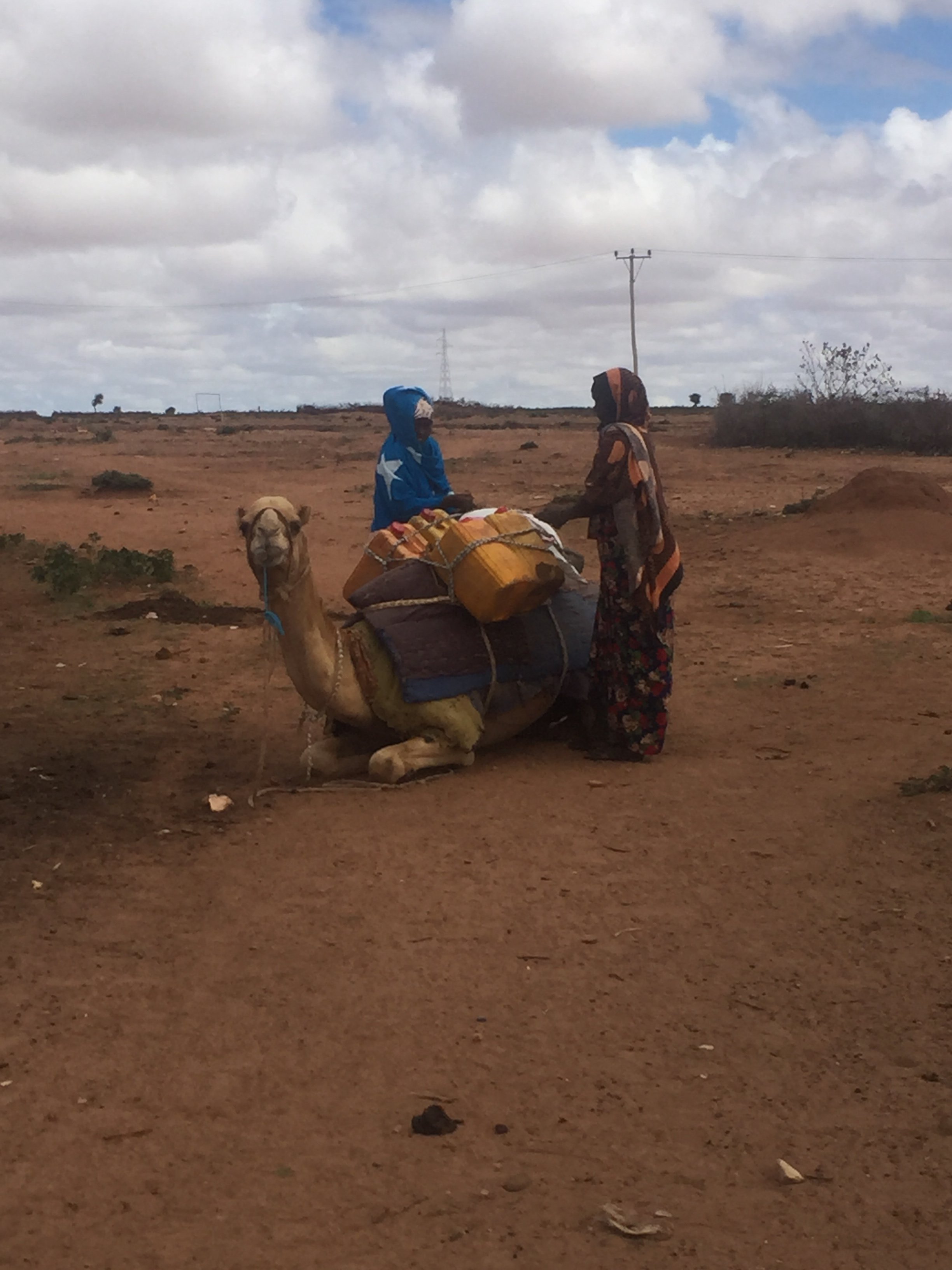
In that visit, we traveled approximately 30 kilometers southeast of Jigjiga to a clutch of modest structures clustered along the main highway: Gilo village. Gilo is in a rural area where the preeminent livelihood is animal husbandry, and we continually saw camels, goats, donkeys, and small cattle being herded along the major roadways and through Gilo itself. Commingled with the fixed buildings were collapsible structures of lightweight, lashed frames covered with textiles, testaments to the nomadic tradition still alive in the region.
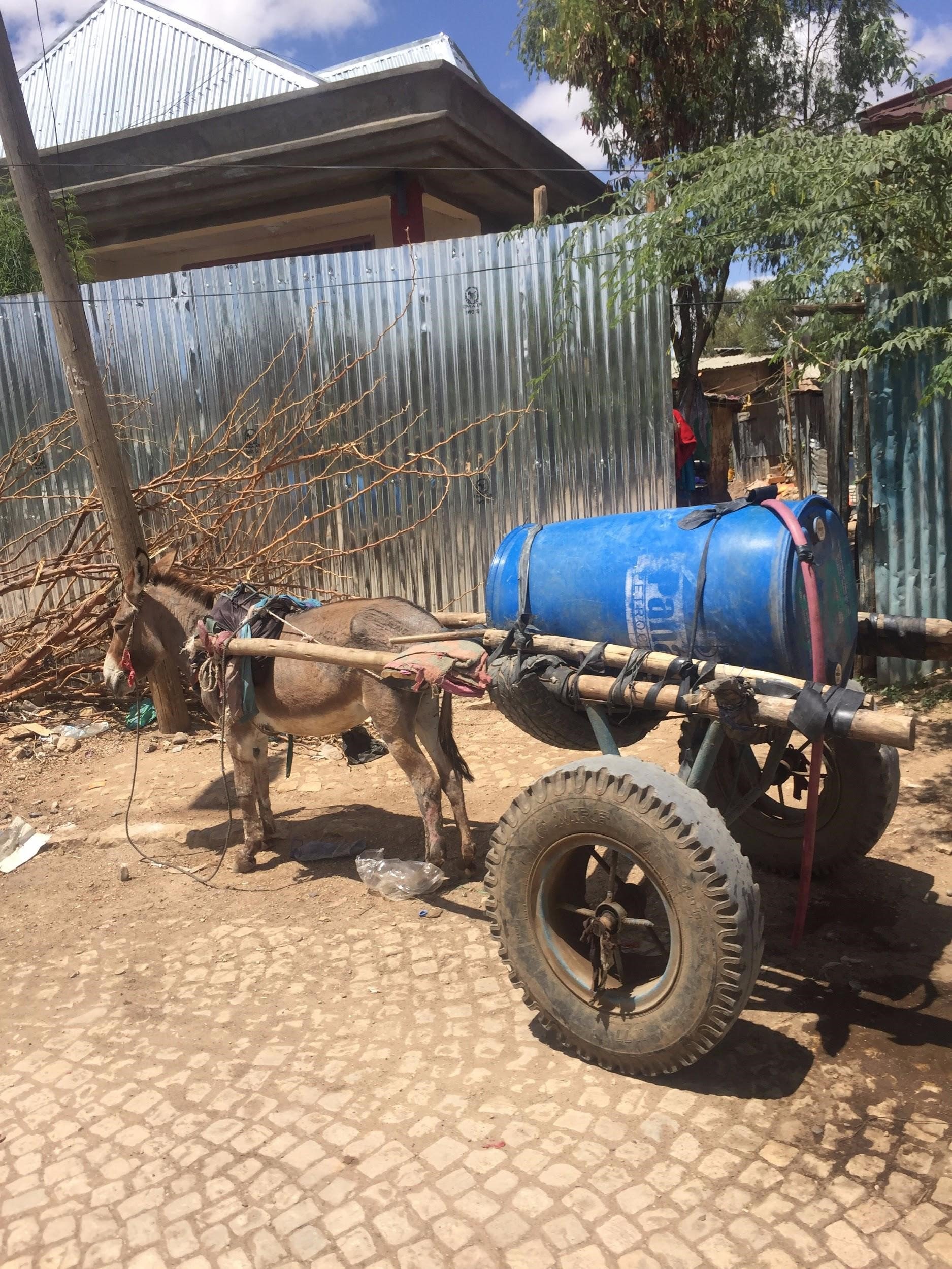
In Jigjiga, drinking and cooking water for many people is sourced from a modest man-made reservoir on the outskirts of the city. The water is pumped by diesel generators into small tanker trucks, driven into town, and delivered door to door by two-wheeled donkey carts. It is neither treated nor clean, but it is seemingly available.
Sharon Burke
In contrast, Gilo village is exclusively dependent on birkads for water. A birkad is an open, rain-fed cistern, which may be earthen or lined with cement. Villagers rely on the semiannual rains to fill all of the cisterns, and then have to conserve that supply for up to half a year—or longer if a rainy season fails to replenish the supply. Because the water is stored in the open, its quality deteriorates continuously. After weak rains in April of this year, the birkads in Gilo were already mostly empty by late May, and the water that remained was green and opaque. Local residents told us that the water was making their children sick.
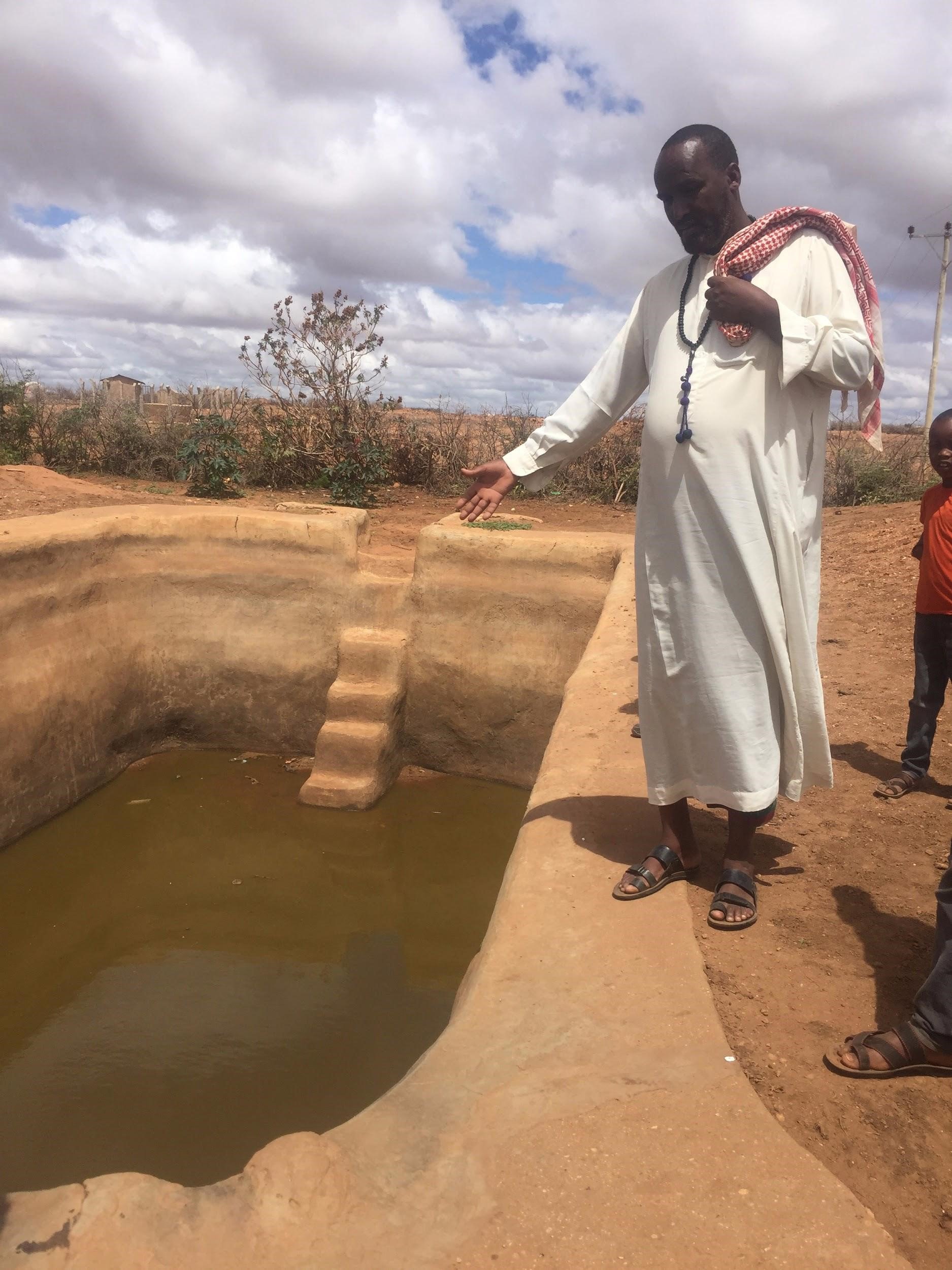
Sharon Burke
The impact of these supply challenges is compounded by the broad importance of water. Mohammed Abdul Hasan, head of the Gilo Rangeland Council, ticked off the critical roles of water in his community: human consumption, sanitation, animal consumption, growing crops for food and income, growing crops for animal feed, and watering livestock for food and income. And as he pointed out, agriculture in the area is typically rain-fed: "There is no familiarity with irrigation here."
Rainfall represents a single failure point, but with consequences spilling downward along a number of possible pathways. The tool opens a window onto some of these pathways, allowing users to see where the risk exposures are greatest, as well as where threats, such as drought, are most acute. This enables rapid risk assessment as well as a means of evaluating and understanding possible conflict drivers.
For example, the prevalence of rain-fed agriculture leaves farmers at the mercy of the weather, exposing them to the risk of lack of food, feed, and income. The tool offers users a view to both sides of this equation: where crops are reliant on rainfall, and where rainfall patterns are deviating from historical norms.
Our visit to the region also highlighted the challenge of localization for a tool like this. The Gilo Rangeland Council told us that a pipeline was supposed to run through their area but that communities on the route had been cutting the pipe in the belief that such a pipeline on their land would reduce the availability of their own water. At the same time, members of the council suggested that there was not a positive relationship between drought and conflict; local families —all one clan—were more likely to cooperate in times of adversity, they told us, and argue in times of plenty.
Vegetation (Araarso Woreda)
Araarso woreda, or district,1 lies a further 40 kilometers southeast of Gilo. The primary water source there is a system of six functional boreholes (a seventh was poorly sited and thus never functional). The six boreholes have to provide enough water for approximately 50,000 people in total and nearly a quarter of a million head of livestock. Because six are not enough, the community also depends on birkads.
Like Gilo village, Araarso district was experiencing drought. A long causal chain links drought to conflict, but the problem is not water scarcity per se. Between boreholes and birkads, everyone in Araarso has access to water, although the borehole water is cleaner. Mohammed Abdul Hasan explained the impact of weak seasonal rains in the region:
When the climate changed [in the past decade], everything changed. Vegetation species that used to grow here exist no longer. In the past, long rains promoted a wide diversity of species. Now only a few persist. This is why you see dry areas [of bare soil]. So now, when the rain comes, the water runs quickly. The water washes away the soil, so there is much less productivity to the land. Also, due to the change, there are new unfamiliar diseases both for the animals and for the humans. Without enough natural-growing vegetation, the community has to buy feed and pay for its transportation, at great expense. This is the damage from the [reduced] rain: water, productivity of land, outbreak of disease. These were formerly unknown, but no longer.
This lack of vegetation—and therefore animal feed—is the critical element. Staff at the district bureaus of water resource and livestock development in Araarso explained the consequences of this shortage, which were not always obvious. While their offices disseminate forecasts to the local populace and report local conditions up the bureaucratic chain, the primary response to forecast information is typically taken at the individual level. This might include such measures as preemptively conserving animal feed or arranging mutual support with other families. We heard similar stories in Gilo, where families had pooled resources the previous year to buy animal feed and transport it to the village, at great expense, when they were unable to grow or graze sufficient stocks.
Another popular response is mobility. Pastoralist families will categorize their animals and select the strongest for travel, sparing the weaker ones from the hardship. These flocks will then be led away from the area, reducing local demand for resources. Often the herders are children; in a similar pattern, it is the stronger, older children who shepherd the animals to more distant grazing. If enough families react in this way, the local school is forced to close because so many students are seeking greener pastures for their livestock.
This is always a temporary shift, not a migration. Movement is on the scale of woreda to woreda—dozens of kilometers, not more. Nevertheless, drought can still put heavy pressure on local resources. And the better the relative state of an area, the more herders and animals it will attract—sometimes to the detriment of that area. One Araarso official was explicit: "When a resource becomes limited and people have to come together to access it, conflict may happen." He and other local officials added that Araarso has a strong tradition of both welcoming others, which brings solidarity, and immediately resolving disputes, which helps keep conflict at the individual level. Notably, in both Araarso and Gilo, the residents seemed to belong to a single clan, so social cohesion there was high. Not all areas, however, benefit from such traditions and social cohesion. Jigjiga, for example, comprises multiple clans and ethnicities, as well as internally displaced persons hailing from other parts of Ethiopia or Somalia.
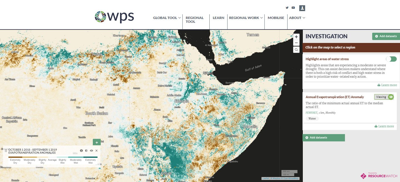
Local conditions and behaviors can link together in a long and complex causal sequence, where individual responses aggregate into larger consequences. For example, when hunger-weakened and unvaccinated livestock congregate, that may lead to mass outbreaks of disease, which can decimate herds and threaten local livelihoods. The tool enables the user to directly investigate the local conditions that are the key links in such causal chains. For example, annual evapotranspiration anomalies can capture deviations in typical vegetative or crop-growing activity, potentially providing an early indicator of poor grazing or scarce feed in the near future-and all that follows such scarcity.
Citations
- Woreda is the third-level administrative unit in Ethiopia, after region and zone.
Decision-making and Model Limitations
Jigjiga, Gilo, and Araarso are not very far apart and face some similar conditions. But looking once more through the lens of water, the three places represent clearly distinct situations. Each relies on a different type of water source; water may be primarily for human consumption, crops, or livestock; the biggest challenge may be supply, access, or quality. The governance structures and resources available vary from place to place, as do the priorities for their allocation. Each place has its own circumstances with their own dynamics, such as social cohesion, dictating its unique linkages between water and conflict.
From the perspective of the model, these three places are not at all distinct: They are all part of the same second-level administrative unit (in this case, a zone). Because this is the spatial unit of analysis of the model, all locations within a zone are treated as one and the same. For each input indicator, a single numeric value is used to represent the entire zone; likewise, the model returns a single value meant to encapsulate the risk for that area.
Some degree of aggregation is necessary for building a global model. Data are simply not available at arbitrarily fine spatial resolution; conflict emerges across a real physical space, not merely at a point on a map. Administrative boundaries often mirror substantive differences in behaviors, practices, and societal structures. In addition, the tool ameliorates this issue somewhat by allowing users to inspect the underlying, unaggregated data.
Nevertheless, this aggregation inevitably blurs or erases variations in conditions within each district. Operating at the granularity of second-level administrative districts, while a noteworthy level of precision, is not nearly fine enough to capture highly localized factors that can shape a conflict. Because information is not consistently available—or even necessarily quantifiable—these elements are effectively invisible to the model. As a result, qualitatively distinct locations become quantitatively indistinguishable.
This is a critical limitation of the utility of the model, and one that is common to such models. Because even when there is a uniform risk forecast across a district, action does not occur at the aggregate level. Investment, infrastructure, food relief, mediation, and other interventions are specific. They happen at particular locations and times, hopefully according to the particular needs of the people there. The benefits, or harms, of a freshly drilled borehole are not diffusely distributed across the unit of analysis, but are localized and inherently uneven. A system blind to the specifics of local challenges and needs cannot guide efforts to address them. At the same time, a local actor who does understand the challenges may have a limited capacity for attracting the needed resources beyond the local community.
Even brief interviews with local actors made it abundantly clear that Jigjiga, Gilo, and Araarso face fundamentally different water security challenges, yet those differences remain largely invisible to the model as currently constructed. And, of course, conflict does not generally stay neatly within the boundaries of a coherent local community. So the question becomes how to make this local nuance available to a quantitative model in a way that would strengthen predictive insights for conflict, especially conflict that might spread.
Local Data
Currently, the model requires globally available indicators. The model cannot train (train being a technical term referring to the parameters of a mathematical model) properly where any input values are absent, and those inputs must be consistent and comparable in order to derive meaningful, generally applicable patterns. Unfortunately, this excludes an enormous corpus of data collected at the national, regional, or even municipal level.
A model can utilize more circumscribed datasets, though, if its geographic scope is similarly limited. As long as each training sample has all relevant inputs available (and these inputs are also available everywhere the model is to be applied) the machine learning techniques will work normally. So a countrywide model can leverage global datasets as well as figures and statistics collected by various national bureaus; it just cannot be applied outside of that country. This opens up a whole new universe of data.
It's not difficult, for example, to imagine datasets that would allow the model or a user of the tool to distinguish between the water situations in Jigjiga, Gilo, and Araarso. National and regional datasets about boreholes exist, for example, showing location, status, and sometimes even water volume and quality. Roughly analogous datasets might exist for birkads, and reservoir data are already available on the tool. One official in Jigjiga told us that 11 people across the district are documenting weather conditions and reporting them regularly via mobile phone. Combining these on-the-ground observations with technical means, such as high-resolution groundwater assessments, could provide a much clearer view of the water situation than is generally available now.
Such untapped data resources abound. Unlocking and accessing them may be no small task, though—it was unclear, for example, how or where those district weather reports were being compiled and collated—but the information exists. Because the methodology1 and the underlying data2 for our model are both freely accessible via the tool, users can fuse the global data table with their own localized datasets to create a specialized model that may be better able to grasp local dynamics.
But, as always, there are trade-offs. A model relying on local data, as indicated, can be applied only locally. The smaller the area of interest, the more datasets there will be that cover it, but at the cost of limiting the model's scope for application and making it harder to trust because of the difficulty of testing it elsewhere. Furthermore, geographic narrowing may in some ways limit the model's ability to evaluate all relevant factors, even as that ability expands in other ways due to the larger pool of available indicators. If the modeled area becomes smaller than the space across which relevant conflict dynamics play out—and neighboring districts or countries are often highly impactful on internal affairs—the model may be blinded to important external factors.
Then there is the political dimension. The model, in essence, tries to connect local conditions with conflict outcomes. When those conditions are rainfall anomalies or vegetative activity, they are uncontentious. Even macroeconomic indicators reflect so many factors and decisions and actions as to resemble intractable natural forces. But zooming in and capturing more and more aspects at an increasingly local level, "conditions" become increasingly specific things, which may represent concrete choices made by particular parties or individuals. For example, one village might have plentiful boreholes while a neighboring village has none. Or two places with apparently similar conditions could experience dissimilar outcomes. The difference may very well be a matter of governance or resource management. But even if this is the crucial differentiator, transforming that into data requires subjective assessments of political activity, which is highly fraught, both technically and politically. For that matter, as noted earlier, the previous governor of Somali region has been accused of gross misconduct, including human rights violations; detailed data on local conditions could conceivably be weaponized by such a politician.
Citations
- [link to technical note and/or analytic scripts for methodology]
- [link to data download page on tool]
Climate Change
The Gilo Rangeland Council was unequivocal on whether recent rainfall anomalies in the Somali region were in fact anomalies or whether they presage permanent shifts in weather patterns: "Drought used to occur every eight to 10 years. Now it is every two or four, or even in consecutive years. This is climate change," one of the officials on the council commented. The populations in places such as Gilo tend to accept a temporarily harsh local climate, with a range of resource management and societal arrangements, but they cannot necessarily endure intense, sustained ecosystem stress. "The old want to stay and continue and struggle," one member of the Gilo Rangeland Council told us, but "young people are demoralized and moving to towns." At the same time, everyone on the council had a cell phone and was well informed of the risks of migration. One man mentioned concerns about seeing television footage of refugees drowning in the Mediterranean while trying to reach Europe.
As we interviewed people in the region about water, weather, and conflict, the issue of climate change loomed over our discussions. The choices people make today are heavily influenced by their expectations for tomorrow. The question of whether to keep the family together in the village or send the children into town hinges on future prospects: will there be sufficient vegetation in the coming years to raise enough livestock to require shepherds–and to feed the family?
Actors such as government bodies, development agencies, and nongovernmental organizations are working to alleviate some of the problems surrounding water in Somali region. Yet they face the same fundamental challenge of making choices today in the shadow of tomorrow. Newly built infrastructure, for example, affects and is affected by conditions today, next year, and 30 years from now. Future expectations are intrinsic to fixed investments with such a long life cycle.
Traditionally, individuals and organizations could look to the historical track record for guidance about conditions in the years and decades to come: average precipitation; onset dates and lengths of rainy seasons; frequency of drought or flooding. But as the Gilo Rangeland Council averred, disruption has displaced continuity in the expectations of locals. And when the past is no longer seen as a reliable predictor of the future, quality long-term decision-making is sorely handicapped.
Climate change projections could fill this gap, by providing a sound, scientific foundation of credible expectations and coherent possible scenarios. Unfortunately, the high-quality, fine-grained climate data that would be of the most use for decision-making is precisely the type of information that is unavailable in Somali region, despite a clear appetite for it at all levels of government. (Indeed, it’s not common for municipalities in more industrialized nations to use this sort of actionable climate data, either.) Climate research and forecasting has advanced dramatically in recent decades, but a large gap remains between what scientists know and what information decision makers have on hand. In Somali region at least, government officials reported having no long-term projections whatsoever. But the value is clear: Locally specific forecasts for temperature, rainfall, or other physical factors could mean the difference between building the right dam or the wrong one—or deciding to build no dam at all.
There are ways that our model could incorporate such climate forecasts. Although projecting future conditions falls well outside the scope of our work, estimating conflict risk under certain scenarios is entirely within the capabilities of the model. Scenario-based estimation of conflict risk is a straightforward matter of inputting hypothetical indicator values into the model. If those hypothetical values for precipitation or evapotranspiration or soil moisture are derived from rigorous climate change projections, our model can produce credible, if speculative, forecasts of the risk of conflict under those conditions.
Other Cases, Other Places
In our consultations with target users of the conflict forecast tool, we heard a number of potential uses. Ultimately, actual project planning requires local context, and even the best curated datasets cannot replace on-the-ground knowledge. The tool can nevertheless be used to communicate to senior leaders where risk is high or growing, and it offers a possible way to prioritize conflict prevention or recovery investments.
In particular, the New America Phase Zero team is interested in how a tool like this may be useful to military organizations in understanding nonmilitary aspects of security situations. Even if water-based solutions are outside the scope of action for militaries, the underlying water-based problems are very much a relevant part of the security landscape. We hope this tool can help demonstrate the relevance with rigorous, quantitative information, and also offer a means to produce more comprehensive security assessments than are currently available to most military and civilian organizations.
In the case of Ethiopia and Somali region, the conflict prediction tool highlighted high conflict risk, as well as some of the underlying drivers of that risk, including water stress. The U.S. government has identified Ethiopia as a strategically significant country and an important regional partner. The stability of Ethiopia is important not just to its own residents, but to the region, the continent, and the world. In turn, Somali region is crucial for maintaining stability within Ethiopia, given its proximity to conflict-torn Somalia, as well as conflict hotspots within Ethiopia. Understanding the nature and magnitude of risk in the area, as well as how to reduce it, is important for promoting national security interests for Ethiopia and for the United States—even if the actual prescription might be investment in improved water management.
The conflict prediction map can provide such insights for other countries where the United States has strategic interests or military operations. Niger and the Philippines are illustrative of the possibilities, and also the differences in how this map may provide insights for different geographic contexts.
Niger, which sits west of Ethiopia in Sahelian Africa, is an important partner to the United States. According to U.S. Africa Command,1 American and Nigerien "militaries have been stalwart allies focused on working together to deter and to defeat terrorist threats in the West African nation and across the Sahel region." The U.S. Department of Defense has a significant presence in the region, including a military base2 near Agadez. While the focus of the American military presence is counterterrorism missions across the region, the United States also has an interest and investment in stabilization and support3 for the host nation of Niger. The conflict forecast tool may not provide the sort of localized data and context necessary for operational or campaign planning, but it can help illuminate the patterns of risk, centers of instability and reasons for it. The tool may help guide the effectiveness of stability investments in the country.
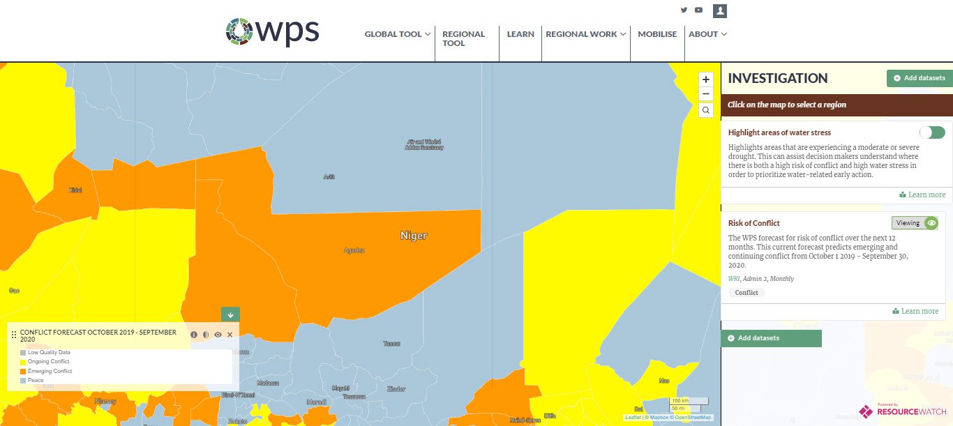
The forecast for Niger is not especially encouraging, with most of the country considered likely to experience conflict, whether new or ongoing. And as shown in the full forecast dataset available for download, in most of the relatively populous southwest especially, the conflict risk is especially high.
The recent ACLED history further highlights the extremely low population density in much of Niger. Closely related is the accessibility of various parts of the country. ACLED events are strikingly correlated with the transportation network, as illustrated by maps showing travel time to the nearest city, although this may in part be an artifact of reporting.
In assessing what is behind the forecasted high risk of conflict, it is worth noting that the Sahel is a famously dry region. Yet precipitation data indicate that conditions have been normal or a bit wetter than usual, and indeed, that description holds for much of the past decade across the entire country. Baseline water stress is high in only a couple of areas, which do not overlap with population centers.
Water supply may not be a driving factor, but the tool allows us to look elsewhere. Nationally, the portion of Niger’s population with access to an improved source of drinking water is lower than in any neighboring countries, with the exception of Chad. The story is the same for access to sanitation facilities, as well as to electricity. Although these could be called development indicators, they also can serve as a proxy for the presence of the state and its capacity to provide services and basic infrastructure for its citizens. It is notable that Niger scores acceptably on a range of governance metrics, including perceptions of corruption and the rule of law.
In other places, the tool tells a different story. The Philippines, for example, is an important partner for the United States of long-standing strategic significance. That interest intensified in the wake of America's "rebalance" to Asia and the strategic competition between the United States and China, which was explicitly recognized in the 2017 National Security Strategy and 2018 National Defense Strategy. Accordingly, actual or potential conflict in the Philippines is a topic of direct strategic interest to the United States—and one that can be explored using our tool.
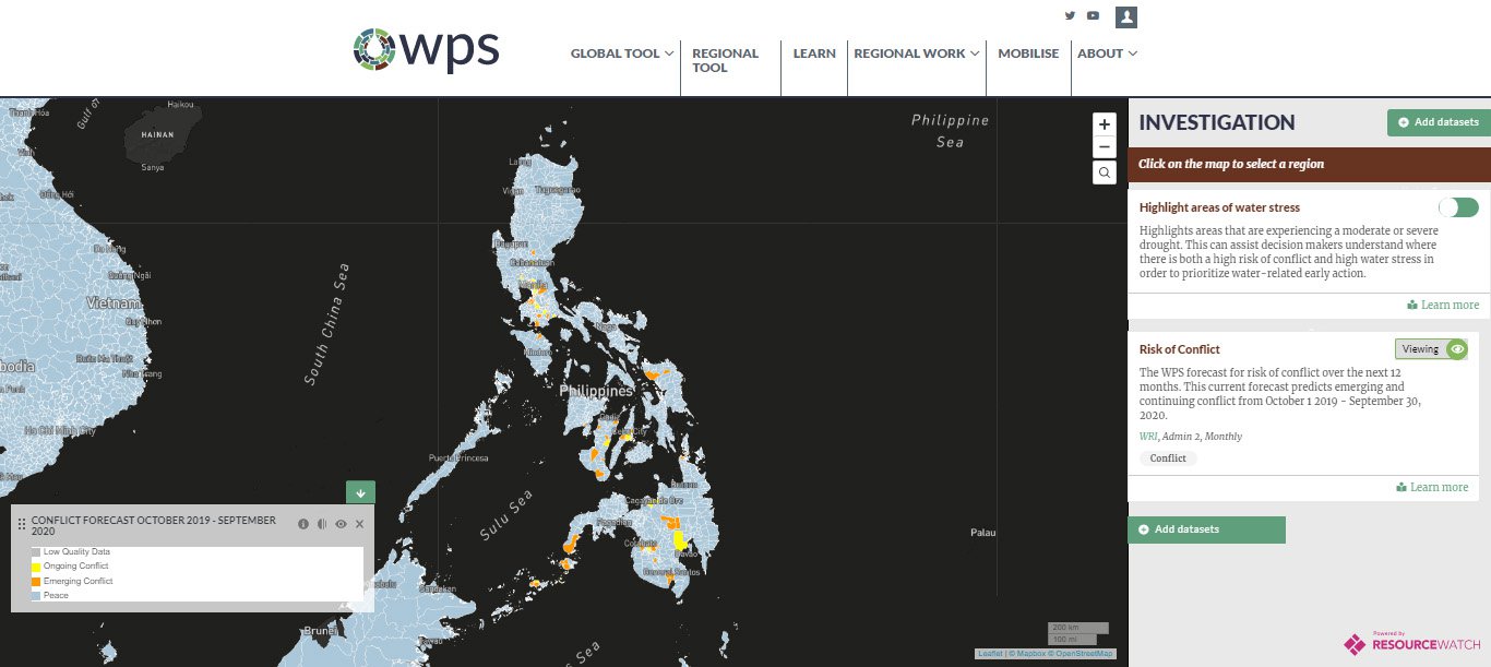
Unsurprisingly, given the violent unrest on some islands in recent years—in some cases rising to the level of insurrection—the model forecasts ongoing as well as emerging conflict in many, though far from most, districts in the Philippines, including several population centers. In this way, the forecast is not totally unlike those for Ethiopia and Niger. Using the tool to look a bit deeper, though, reveals a very different story. This outcome is not totally unlike the forecast in Ethiopia or Niger. Using the tool to look a bit deeper, though, reveals a very different story. Baseline water stress in the Philippines is low for most of the country. Seasonal water supply variability is similarly low, and even interannual variability is moderate. Riverine flood risk, meanwhile, is exceptionally high. But this represents a very different type of challenge to locals and government bodies. In general, the Philippines does not appear to be water-stressed.
High conflict risk in the absence of high water stress serves to highlight the fact that the model tries to predict conflict risk, not the risk of conflict due to water. Although water is often omitted from discussions and analyses of conflict among traditional national security analysts, and our research attempts to redress that oversight, this does not imply that water plays a significant role in every conflict. Completely different factors—among them political, economic, and ethnic—may drive conflict. Although the tool itself emphasizes water, it also allows users to explore other factors. In the Philippines, recent conflict history is obviously germane to the prospects of future conflict; the density of events and, in particular, the frequency of violence against civilians would seemingly augur poorly for peace.
Conclusion
Ultimately, conflict is a human activity, and the actions of human beings can be hard to predict. At the same time, conflict does not happen in a vacuum: Even if the specific catalyst of violence can be hard to divine, the conditions most likely to encourage violence are knowable. The Water, Peace and Security team consulted dozens of experts and conducted extensive research to gather data on those conditions, testing which variables were most indicative of future conflict. The model cannot perfectly predict where and when violent conflict will occur, of course, but it can provide insights as to where conflict is likely, and what might be its underlying drivers. One of the most powerful indicators is also one of the most obvious: a history of conflict often begets more conflict.
Nonetheless, such foresight can give local, national, and international actors insights into how to mitigate the risk of violence. And while the model cannot tell an international organization exactly what investment in which local water system will have the greatest impact, a local water authority cannot always access the same expertise or resources as a large international organization when it needs help making such an investment. This tool can help close the information gap between high-level decision makers and at-risk localities or regions. The Water, Peace and Security partnership, in fact, intends to use this model to inform and prioritize its investments in fieldwork in high-risk countries. Inclusion of climate change projections would greatly enhance that work.
While such predictive models hold great promise for understanding the drivers of conflict and how water and other factors affect risk, there are also limits to what these models can or should do. On a practical level, there is that unmappable corner of human nature, as well as highly localized dynamics that cannot necessarily be generalized. There is also an underlying risk that modelers need to take seriously and discuss openly. The aggregation of such a volume of data constitutes a powerful tool that can be used for ends that are good as well as those that are not so good. Model development should bear in mind the medical profession’s cornerstone principle primum non nocere, or “first, do no harm.” Household-level data, for example, may illuminate underlying drivers for instability and discontent with unprecedented clarity—and simultaneously offer unscrupulous actors a detailed road map for targeting restive individuals. The sad truth is that a region at high risk for conflict is likely also at high risk for human rights violations. For that matter, national or international actors that use data to design local interventions without consulting the local population may do as much harm as good. So, while fine-grained, local data might afford a model greater fidelity, designing the model so that its forecasts can be translated into action only with the cooperation and engagement of local actors may ultimately lead to better outcomes.
Finally, it is worth considering that U.S. armed forces make extensive use of such models and simulation. Even though their models are no closer to perfect predictions than this one, they inform billion-dollar decisions about how to organize, train, and equip military forces. Given what is at stake in national defense, being unprepared is not an option, and making such significant decisions without the best available information would be unacceptable. Yet civilian organizations facing issues every bit as significant as those of the military—how to prevent a war or alleviate human suffering—do not routinely utilize such decision support tools. Hopefully, our conflict forecasting website will prove a valuable tool, and encourage the use and expansion of such decision support tools in this sphere.
Sharon Burke
More About the Authors