Table of Contents
Part I: A Region of High Risk
Indo-Pacific Disaster Trends in a Changing Climate

Disasters have long been a common feature of life, from the Indian subcontinent to the South Pacific Islands. Ocean currents, continental, arctic, and tropical winds, tectonic plates, dramatic and varied topography, and even the tilt of the Earth all combine to create a complicated and, at times, violent natural environment in the Indo-Pacific region. In recent decades, many countries in the region have improved their disaster management and response, which has lessened the toll of the earthquakes, tsunamis, storms, and floods that can ravage the area. Unfortunately, global climate change has started to change weather patterns in ways that are likely to increase water-, weather-, and climate-related hazards. At the same time, growing populations and social vulnerability mean more people are exposed to natural hazards. Still, disaster risk exposure, or what the United Nations calls “the riskscape,”1 will continue to depend on how well communities can absorb and mitigate these changing hazards.
The majority of severe disasters in the Indo-Pacific area fall into two categories: hydro-climatic disasters (floods, droughts, tropical cyclones, and extreme heat) and geophysical disasters (earthquakes, tsunamis, and volcanoes). Between 1990 and 2017, geophysical hazards, specifically earthquakes and associated tsunamis, were the deadliest and costliest disasters across the region, followed closely by tropical cyclones, a hydro-climatic phenomenon (Figure 2).
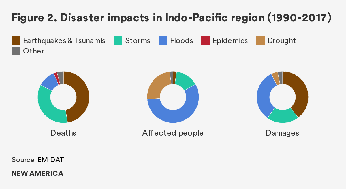
Major riverine floods and droughts, which are also hydro-climatic, affected the largest number of people but led to fewer deaths overall. Other types of disasters, such as epidemics and nuclear accidents, have accounted for a relatively small portion of reported disaster impacts in recent decades.2 Climate change will have broad effects across the first category of hazards, hydro-climatic disasters.
This report was finalized just as the World Health Organization declared COVID-19 a pandemic, and only a few months in, this event already seems likely to eclipse all other disasters in scale and economic impact, if not in direct loss of life. Epidemics have caused far fewer deaths than other disasters in recent decades, thanks to advances in modern medicine and governments’ ability to contain them, but it is not clear if that pattern will hold with the current pandemic.
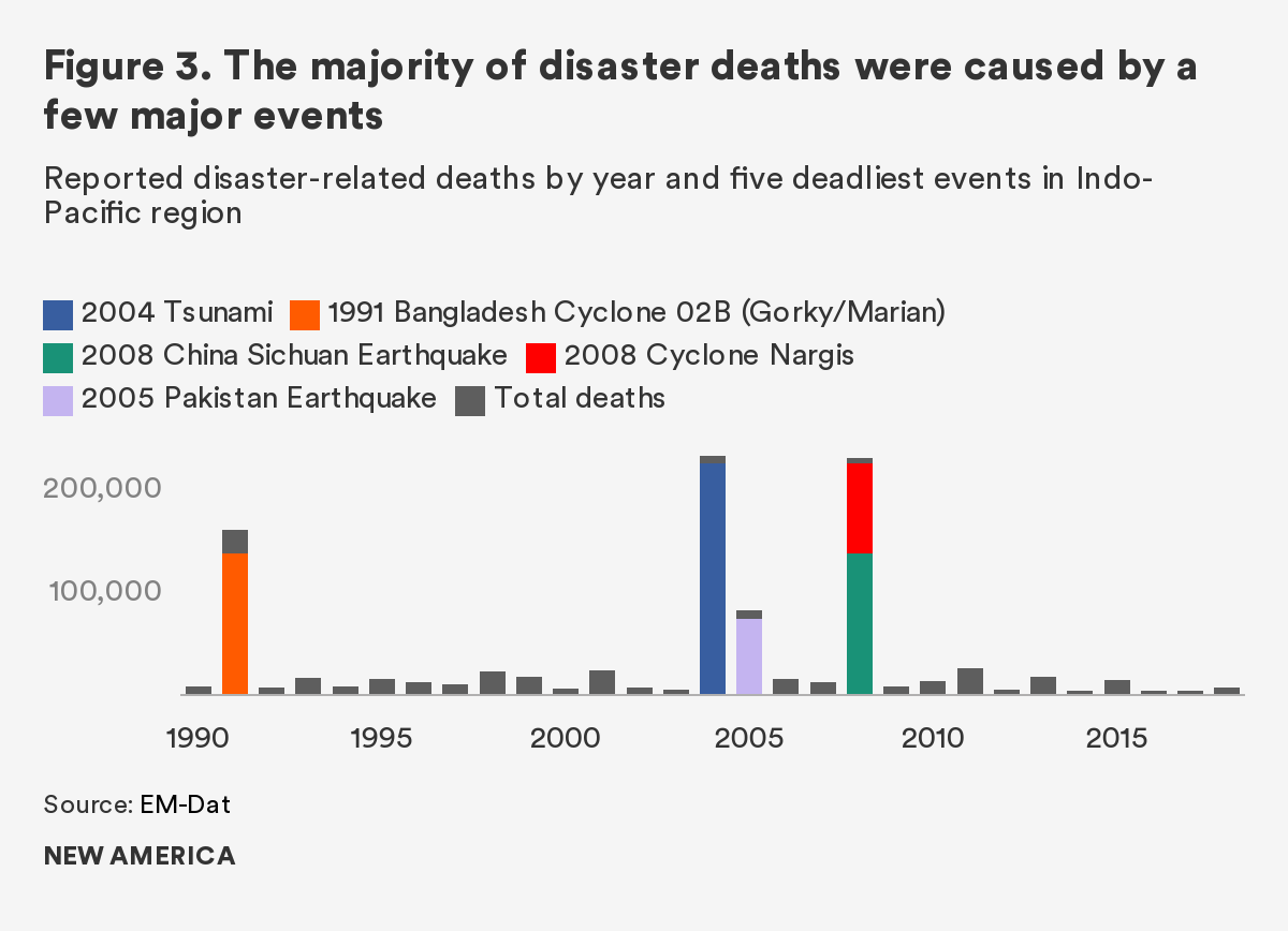
All disasters are by definition exceptional, but they are not all created equal: a handful of truly severe events have inflicted the vast majority of damages in the Indo-Pacific area in recent decades. Of reported disaster impacts in the region between 1990–2017 in the region, just five events accounted for nearly two-thirds of disaster-related deaths (Figure 3).
Such extreme events can overwhelm even the best prepared communities and generally mean long recovery times. Japan, for example, is a leader in disaster management, yet the 9.0- magnitude earthquake that hit off the coast of Tōhoku in 2011 and the massive tsunami it generated—estimated at a wave height of 33 feet in places3—were too much for even Japan to handle. The tsunami arose too close to shore for warning systems to give many people time to evacuate, overtopped sea walls designed for smaller waves, and destroyed critical infrastructure not designed for such inundation, including the Fukushima Daiichi nuclear reactor.4 The reaction to the novel coronavirus epidemic unfolding around the world shows the same weakness to the most extreme events on a global basis. When local systems are overwhelmed in this fashion, prompt and practiced relief can make all the difference in reducing loss of life in the immediate aftermath.
Earthquakes and Tsunamis
Frans Delian / Shutterstock.com
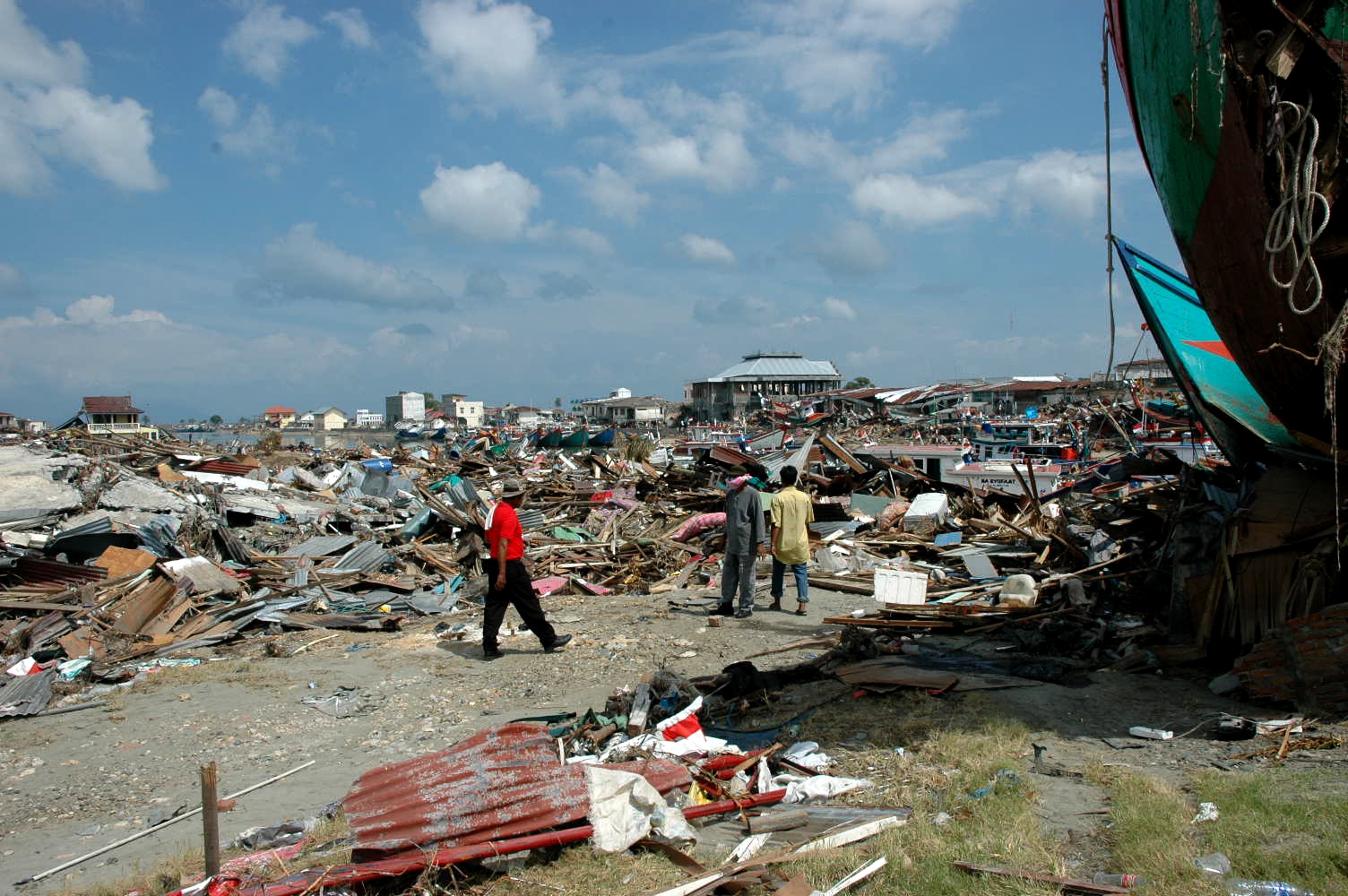
Historically, the most deadly and costly disasters across the region have been earthquakes and associated tsunamis. The Indo-Pacific region contains several highly active tectonic plate boundaries, forming the western flank of the Ring of Fire, as well as the boundary between the Indian and Eurasian plates. Earthquakes in Pakistan, China, and Tibet have been some of the deadliest disasters in the world. A high coastal population is also exposed to tsunamis that propagate outward from marine and coastal earthquakes. The 2004 Indian Ocean earthquake and tsunami alone caused over one-fifth of reported disaster deaths in the region between 1990-2017. The region also has a significant amount of volcanic activity, which is certainly dramatic but more localized in its effects.
Earthquakes are sudden-onset disasters that happen without opportunity for warning. Beyond emergency management and disaster preparedness, the primary way in which regional governments minimize the damage of these events is by ensuring structures are built to absorb or withstand earthquake vibrations. Measures such as building codes and enforcement of standards can be effective at minimizing deaths and injuries, though physical damages to infrastructure can still lead to major economic disruption and losses. Despite Japan’s high level of earthquake preparedness, for example, the 1995 Kobe earthquake was one of the costliest disasters recorded in the region, with an estimated 6,000 deaths. On the other hand, the 2008 Sichuan earthquake in China killed some 70,000 people and injured hundreds of thousands, a high human cost attributed in part to buildings that were constructed prior to the adoption of seismic building codes—or the builders who ignored the codes.5
Early warning systems, physical infrastructure, such as sea walls, and other preparedness measures can also reduce the impact of tsunamis. After the 2004 Indian Ocean tsunami, there was a concerted effort to improve regional early warning systems, which include NOAA’s Pacific Tsunami Warning Center. These systems are by no means infallible, nor are they always well maintained. Numerous media outlets pointed to the inadequacy of Indonesia’s early warning system after a 2018 tsunami, for example.6 Even well-maintained systems can be overwhelmed, as was the case in Japan’s 2011 tsunami.
The long lag time in improving existing structures and short-term economic incentives to bypass safety regulations imply that earthquake vulnerability will remain high. Likewise, a worldwide trend toward littoral population growth and development suggests that tsunamis will remain a significant risk for the region.
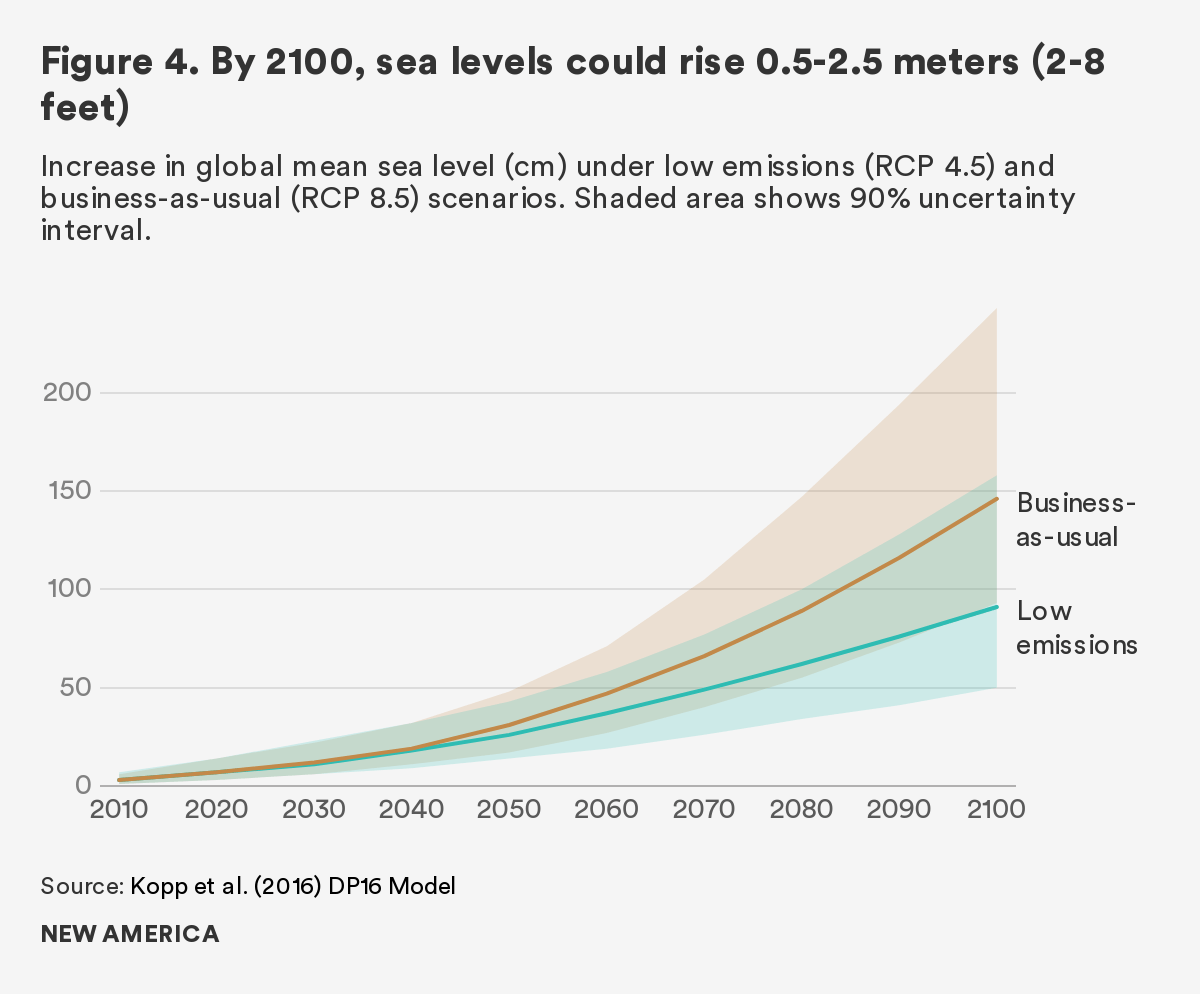
Although climate change does not generally affect earthquakes and tsunamis, in certain regions, climate change likely increases the risk.7 In Nepal, for example, higher temperatures are melting glaciers, which in turn may trigger local seismicity. Sea level rise from melting ice sheets will also increase exposure to tsunamis. Through mid-century, sea level rise is projected to be relatively slow but will accelerate as climate feedback loops intensify.8 Global sea levels are projected to be 0.2–0.5m (0.6–1.6ft) above year 2000 levels by 2050, but could rise as much as 1–2.5m (3–8ft) by 2100 under a worst-case climate scenario (Figure 4). Nonetheless, the most important factors for these disasters will be a growing risk exposure, given population growth in disaster-prone regions, and the offsetting effect of investments in disaster preparedness and mitigation.
Tropical Cyclones
After earthquakes and tsunamis, tropical cyclones are the leading cause of disaster-related deaths in the Indo-Pacific region. Major cyclonic storms bring three different hazards to affected regions: storm surges (high water levels driven by winds and air pressure that can flood coastal areas); high wind speeds; and flooding due to torrential rainfall. Tropical cyclones tend to have the greatest impact on coastal areas, because of both storm surges and the rapid loss of energy as the storms travel inland. Nonetheless, these storms can still cause significant flooding in inland regions.
Because tropical cyclones only occur under specific conditions, the level of hazard varies widely across the region (Figure 1). The vast majority of storms occur in the Western Pacific Basin, with the Philippines weathering nearly 20 storms per year. On the other hand, though the Northern Indian Basin receives fewer storms, the two deadliest storms since 1990 occurred there (1991 Cyclone Marian affecting Bangladesh and 2008 Cyclone Nargis affecting Myanmar). The shape of the land can also affect the severity of storm hazards. For example, the shallow and triangular shape of the Bay of Bengal off the coast of Bangladesh and low-lying land makes the area particularly prone to widespread flooding from storm surge.9
New weather satellites and computer models have greatly improved the ability to track and forecast tropical cyclones over the past three decades.10 Combined with strong disaster preparedness plans and public awareness, early warning can greatly decrease loss of life. Physical measures such as cyclone shelters, coastal embankments, and restoration of coastal forests and mangroves can also reduce the impact of storms.
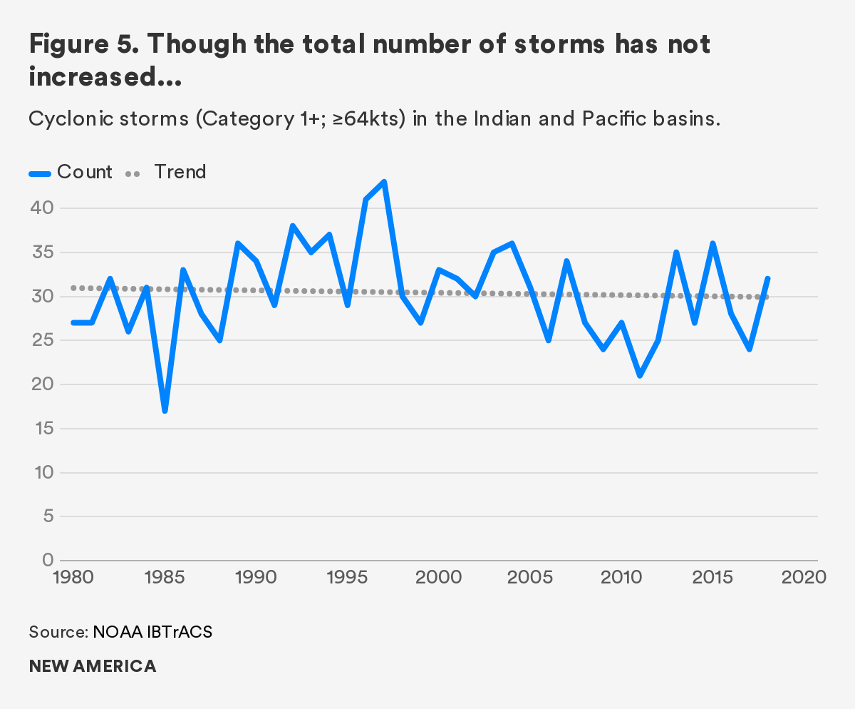
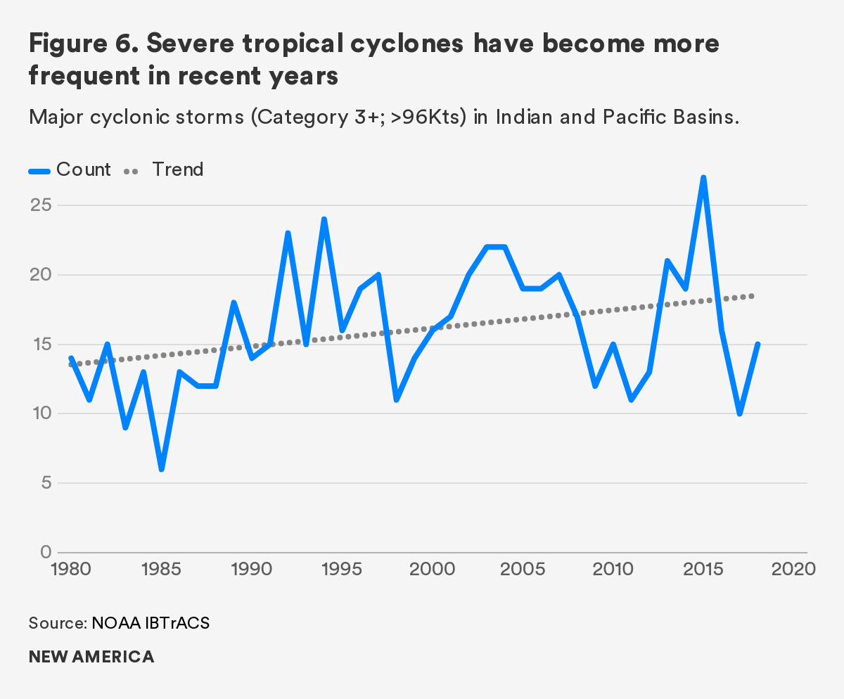
The United Nations Intergovernmental Panel on Climate Change (IPCC) and other scientific experts generally expect that climate change will increase the severity of tropical cyclones as warmer oceans fuel larger storms.11 The effects of climate change on tropical cyclones are likely to be most pronounced at the extremes. Recent research suggests that the total number of tropical cyclones is unlikely to increase under a warming climate, but that the number of severe storms is likely to increase.12 Higher temperatures may also enable a northward shift in storm tracks.13 Indeed, historical storm data suggest that this may already be occurring. There has been a slight upward trend in the number of major storms between 1980–2018 in the Indian and Pacific basins (Figures 5, 6).
Additionally, warmer temperatures will increase the flood impacts of tropical cyclones. As warmer temperatures increase the amount of moisture in the atmosphere, tropical cyclones are able to produce more precipitation. Sea level rise will also increase baseline exposure to storm surge. Several studies of Hurricane Harvey, which caused record flooding in Texas in 2017, suggest that global warming may have accounted for 15–40 percent more rainfall than would have otherwise occurred.14 Although storm wind speeds often get more attention, flooding and associated damages are the main cause of humanitarian disaster in the wake of such storms.
This increase in extreme storms is of particular concern, as the most severe storms cause the majority of deaths and damages. Furthermore, it is difficult for communities to build for the least frequent but most extreme events. This means that measures to mitigate damage, such as early warning systems or flood control infrastructure, are likely to be overwhelmed by the biggest events. More severe storms in a warming climate may mean an inescapable increase in demand for humanitarian assistance and relief efforts.
River Floods
Floods have been some of the costliest and most widespread disasters in the Indo-Pacific region. Although flooding can occur at any scale, widespread flooding is most likely to occur in the floodplains of major river basins with large catchment areas. Sustained heavy precipitation can also cause widespread flooding where there is insufficient drainage.
Modern flood management often combines infrastructure, such as dams and levees, and non-structural approaches, including restricting development in floodplains and restoring upstream vegetation and wetlands. At the same time, human interventions have also worsened river flooding. Humans have farmed fertile river floodplains for thousands of years, but in the last century growing populations and demand for agricultural land have pushed more and more people onto floodplains. In the past, people dealt with seasonal floods largely by moving; control measures to protect higher farm and population density sometimes prove to be counterproductive. While infrastructure such as embankments can protect people in reclaimed floodplains from seasonal floods, they also confer a false sense of security, given that severe floods can still overtop embankments.
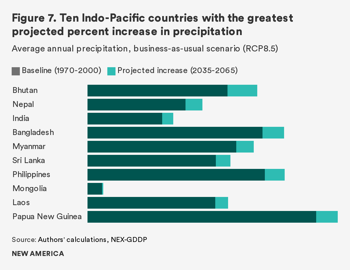
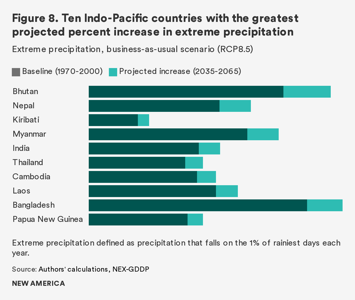
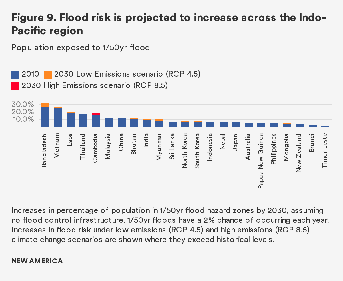
Scientific studies conducted by the United Nations Intergovernmental Panel on Climate Change and others project that a warming climate will increase flood risk. In general, experts anticipate that global warming will drive greater extremes in weather, with drier dry seasons and wetter wet seasons. More specifically, both average annual precipitation rates and extreme precipitation are projected to increase across the region (Figures 7, 8). Flood models from the World Resources Institute15 show increases in river flood risk across many countries in the region, absent additional flood protection (Figure 9). Flood control is typically designed based on historical magnitudes of flooding. Increases in flood magnitude may overwhelm historical infrastructure, and severe flood levels are likely to occur more frequently than previously anticipated.
Importantly, river flooding is largely predictable and within human’s ability to control. For example, China’s Yangtze River is historically flood prone. Channelization and development along the river in the early 20th century increased risk of flooding, leading to a number of historically devastating floods, notably in 1931, 1954, and 1998.16 Following flooding in 1998, new reservoir construction, development restrictions, reforestation, and reconnection of seasonal lakes substantially reduced the risk of flooding on the lower Yangtze. It is likely that countries will continue to invest in flood control, and risk of widespread flooding will decrease over time.
Drought
Hypervision Creative/Shutterstock
Although droughts lead to widespread natural disasters in the region, their overall costs and deadliness are usually lower than that of other disasters. Nonetheless, droughts often have the greatest impact on poor populations, and can lead to increased poverty, migration, and insecurity. Drought risk is likely to increase due to greater variation in precipitation, higher temperatures, and increased water demand, although some areas may see decreases in certain types of drought.
Drought is a relative condition, defined by a population’s water use.17 In other words, drought is not simply the absence of water, but an insufficiency of water at the right time and in the right place. For rain-fed agriculture, for example, a period without precipitation during critical points in the growing season or a late onset of the monsoon season can wither crops. This form of meteorological drought is likely to increase across the region, with drier dry seasons and greater variation in monsoon behavior.18
The unavailability of water for domestic consumption, irrigation, and other uses is called hydrological drought. Its occurrence depends on water storage and usage as much as precipitation, and often develops over a long time period. The impact of climate change on hydrological drought will be varied. Warmer temperatures are likely to increase average annual water supply as well as crop water demand due to higher precipitation and evaporation rates. For areas with large-scale water storage infrastructure, such as much of China, climate change may increase the amount of water available. On the other hand, areas that depend on snowpack for water storage, such as Australia’s Murray-Darling Basin, will likely face increased hydrological drought risk.
In many parts of South and East Asia, water stress is already a significant issue. Major groundwater aquifers under the Ganges River Basin in India and Bangladesh as well as northern China have been significantly depleted over the past several decades.19 Increasing water demand due to population growth, economic development, and increased evaporation is likely to further reduce countries’ abilities to buffer shortfalls. While climate change will increase risk for rainfed and subsistence agriculture, other forms of drought risk will depend more on how countries manage the use of their water resources.
Climate, Health, and Disasters
Climate change will have both direct and indirect effects on human health. Most directly, higher temperatures and increased heat waves are known to increase mortality, especially for elderly populations.20 Although tropical regions are more resilient to extreme heat, lack of air conditioning in less developed parts of the region may limit options for reprieve.
In general, the viability, transmission, and mortality of many diseases are linked to climate conditions. Higher temperatures will increase the habitable range of disease vectors—in particular mosquitos, which can carry malaria, dengue, zika, and encephalitis. Rainfall and flooding also improve conditions for mosquito reproduction, and may increase the severity and frequency of outbreaks. Excessive rainfall and warmer temperatures may also increase transmission of water-borne diseases, such as cholera and common diarrheal diseases. On the other hand, certain diseases, such as influenza, are traditionally associated with cooler weather. The relationship between many diseases and climate, let alone climate change, is not fully understood.21 In the case of the ongoing COVID-19 outbreak, for example, current scientific speculation is that warmer weather will not stop the spread of the virus, as is common with influenza.22
Disasters may compound the risk of disease outbreaks by destroying or disabling critical infrastructure. Widespread blackouts, lack of clean water and sewage infrastructure, disruption of healthcare services and flooding in the aftermath of severe storms or other disasters may hasten disease transmission and increase mortality—for example, the severe outbreak of cholera after the 2010 Haiti earthquake. Risk of compound disasters, such as coincidence of heat waves and tropical cyclones may also increase.23
Note that the current novel coronavirus outbreak reflects a different facet of disaster risk, one that also interacts with climate change: the increasing exposure of growing populations to natural hazards. It is likely the virus behind COVID-19 migrated from wild animals to humans, in part a reflection of rising human population density and land-use changes in the habitat of these animals.24
Other Hazards
Smaller-scale localized hazards such as landslides and glacial lake outburst floods may also see an increase in frequency with climate change. Though both of these hazards usually only affect small areas, they can be devastating due to their speed of impact.
Landslides are often associated with extreme precipitation and earthquakes. Slopes that are vulnerable to landslides may also be weakened by road construction and removal of vegetation. Increased incidence of extreme precipitation is likely to result in a greater risk of landslides, as saturated soils are less able to bear weight.25
Glacial lake outburst floods occur when landslides, avalanches, or earthquakes cause alpine lakes to overtop their terminal banks, releasing lake water downstream. Occurrence of outbursts is likely to increase with glacial melt, which is increasing at a rate unprecedented in recorded history.26 Although the remoteness of glacial lakes means that most at-risk valleys are sparsely populated, they may be a particular concern for montane countries such as Nepal.27
General Climate Impacts
Rising global temperatures will have widespread effects on the Indo-Pacific region. In addition to increasing disaster risk, climate change will increase stress on both human and ecological systems. Although there is uncertainty about specific impacts and the changes will likely be gradual over the coming decades,28 there is substantial evidence the region is already experiencing climatic change.
The speed and magnitude of change are tied to global greenhouse gas emissions. The majority of modern climate model runs evaluate two future scenarios for greenhouse gases: (1) a low emissions scenario in which global greenhouse gas emissions peak and decline by 2040, limiting warming to around 2–3ºC (4–6ºF) by the end of the century (RCP 4.5), and (2) a business-as-usual scenario allowing global average surface temperatures to increase by 3–6ºC (6–11ºF) by 2100 (RCP 8.5).29 From a global policy perspective, the low emissions scenario corresponds to an aggressive pursuit of the 2015 Paris Agreement,30 in which countries rapidly reduce emissions beyond current voluntary commitments. That does not seem likely at this time, at least as a matter of deliberate policy. Over the next few decades, differences between the scenarios are primarily a matter of magnitude of change. However, dramatic shifts with less predictable consequences, such as the reversal of ocean currents and breakdown of ecological systems, become more likely above 2ºC of temperature increase.31 It is worth noting that despite global commitments to reduce emissions, as of 2019 global greenhouse gas emissions continued to increase. The COVID-19 pandemic appears to be causing a steep decline in emissions, a second order effect of a slowing global economy. How steep and persistent that drop is depends on how long the negative downturn lasts.
In general, the impacts of climate change relate to the physics of higher temperatures and how they affect weather and water. Higher temperatures increase evaporation rates and allow the atmosphere to hold more water, resulting in larger but more infrequent storms. Over much of South and East Asia, the summer monsoon drives seasonal weather patterns, with warm summer air rising over the subcontinent and pulling in moisture from the ocean. In most climate simulations, this monsoonal behavior is projected to become more intense, with drier dry seasons and wetter wet seasons. However, there remains some uncertainty in regional monsoon predictions.32 Decreased winter snow accumulation and increased melt rates will also affect seasonal river flows. Melting of the Antarctic and Greenland ice sheets and the expansion of ocean water from higher temperatures will raise sea levels over the coming centuries, or possibly sooner, if certain tipping points occur.
Though socioeconomic trends are likely to remain the main drivers of human security across the rapidly developing Indo-Pacific region, communities will need to adapt to climate change effects on agriculture, energy, health, and ecological systems. In some cases, these changes may exacerbate existing stresses, such as depleting groundwater reservoirs. Box 1 summarizes likely climate-related impacts across the region, excluding disaster risk.
Summary of Climate Impacts for Indo-Pacific region
Temperature:33 Average temperatures are projected to increase more rapidly closer to the poles than in the tropics. However, extraordinarily high temperatures will be more common for tropical areas that experience less background variation. Many areas will experience extreme heat levels much more frequently and for longer periods than in the past.
Precipitation: Annual precipitation rates are projected to increase across the region, but greater variation in precipitation is expected. In addition, the frequency and intensity of extreme precipitation events are expected to increase.
Sea level rise: Global sea levels are expected to rise an average of 0.9m (3 ft) to 1.6m (5 ft) by 2100.34 Because the melting of ice sheets will lag behind other climatic changes, sea level rise is expected to be slow in the near term but will continue to accelerate through the coming centuries. Nonetheless, sea level rise is an existential threat to many island states and delta populations.
Agriculture: The impacts of climate change on agriculture will be varied, with some areas potentially seeing positive change while others suffer. Higher temperatures will increase heat stress for certain crops and increase crop water demand, though they may extend growing seasons in colder climates. Increased variability in precipitation will affect rainfed agriculture and increase drought risk. Similarly, greater seasonal variation in river flows will increase the need for water storage to maintain large swaths of irrigated cropland across the region and is likely to put greater demand on groundwater resources. On the other hand, regions downstream of glaciated highlands may see increased irrigation water availability as these long-term stores of water are released. Projections of the impact of global warming on crop yields remain uncertain, in part due to uncertainty around the net effects of CO2 fertilization.35
Fisheries: Extensive coral reef bleaching is likely to occur under 2ºC of warming, severely damaging coastal fisheries and reducing tourism potential.36
Energy: Greater variability in river flows may limit hydropower output during the dry season and put competing demands for flood control on reservoirs during the wet season, though higher total precipitation may increase overall hydropower output. High temperatures may also limit energy generation of thermal power plants which rely on cooling water to operate.37
Security: Increasing water scarcity, sea level rise, and disasters will likely drive increased migration, which may exacerbate existing tensions and strain governments. Increased water and energy insecurity may also raise inter-state tensions.
Concentrations of Risk
In addition to the high frequency of natural disasters, the Indo-Pacific region is home to around 60 percent of the global population, including the majority of the world's low-income people.38 As the region continues to experience rapid population growth and urbanization, the concentration of people at risk will rise, and climate change will compound that risk. In particular, there is likely to be an increase in the number of complex emergencies, or humanitarian crises of such scope and scale (often including internal conflict or violence) that they exceed or disrupt the ability of local civil authorities to respond and require national or international assistance. This will mean an increase in demand for global humanitarian and disaster relief, including from the United States and, in particular, from Indo-Pacific Command, given the region’s population and susceptibility to disasters.
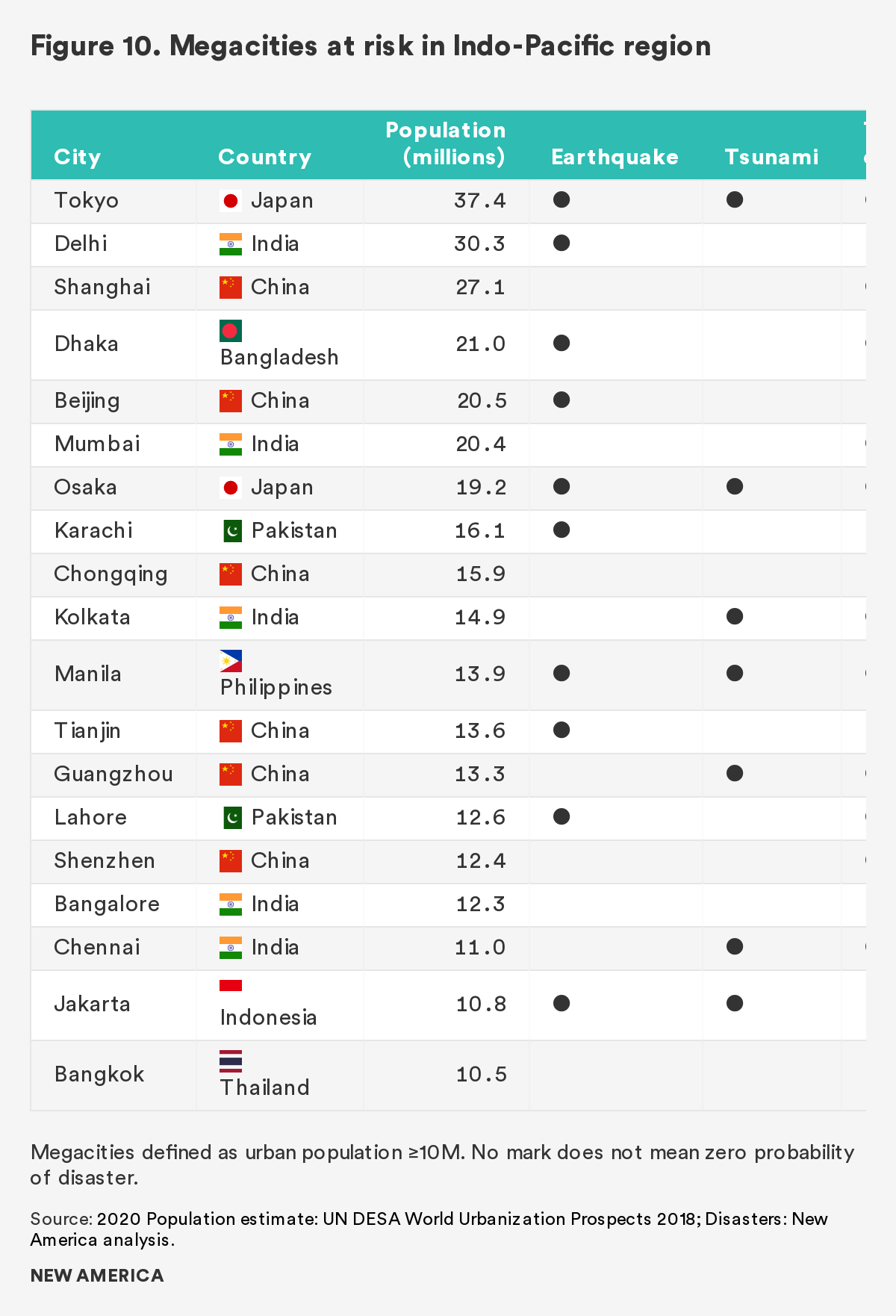
Of the 36 countries in Indo-Pacific Command’s area of responsibility, seven have particularly high disaster risk, a history of U.S. humanitarian and disaster relief missions, and high relative strategic importance for the United States. Only one of those seven, India, has significant military capabilities for humanitarian and disaster relief. In addition, megacities (metropolitan areas with a population of more than 10 million) across the region deserve additional focus, given the concentration of risk.
Risk for natural disasters depends on a confluence of factors, mainly the exposure of people and economic assets to hazards and the community, regional, and national capacity to cope with and recover from disasters. Past events can help guide estimates of exposure to hazards, though vulnerability or resilience to these hazards is often estimated indirectly. In particular, low-income populations may have few options to evacuate, absorb, and recover compared to wealthy populations, and that fragility may not be well documented. Robust infrastructure can lessen disaster impacts and reduce the risk of follow-on hazards such as water-borne disease outbreaks. Competent governance also reduces the risks and impacts, but weak governments may lack institutional capacity to rapidly respond, and corruption and inefficiency may hamper recovery efforts.
The extreme population density of megacities makes them especially vulnerable. Globally, urban populations are growing faster than rural populations, and by 2050 it is estimated that 68 percent of the world population will be living in cities. South and East Asia hold the majority of the world’s megacities with 20 of the 33 cities with populations over 10 million. By 2030, six more Asian cities are projected to cross the 10 million threshold: Hyderabad, Ahmadabad, Ho Chi Min City, Chengdu, Nanjing, and Seoul.39 Major cities also function as economic hubs regionally and increasingly globally. Disruptions to city functioning can have knock-on effects around the world, as is being demonstrated by the COVID-19 pandemic.

Maciej Zarzeczny/Shutterstock
Assessing risk in megacities is challenging due to the complexity of their topography, infrastructure, governance, and the transitory nature of some of the population. For example, remote sensing and GIS imagery can show the effect of flooding, but understanding urban flooding also requires hydrodynamic analysis of city drainage systems.40 Nonetheless, cities across the region stand out due to their size and exposure to natural hazards. For that reason, in the section that follows, we will indicate when one of the most risk-exposed nations also contains a megacity.
Bangladesh
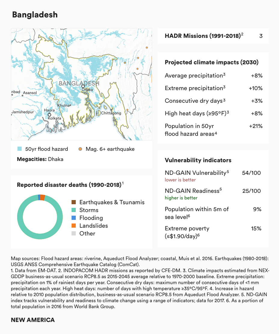
Bangladesh’s low-lying topography makes it prone to both floods and storms. The majority of the country constitutes the lower floodplains and delta of the Ganges, Brahmaputra, and Meghna rivers, which swell annually with the summer monsoon. Bangladesh is the most flood-prone country in the region, with over a quarter of its population living in areas that could be inundated by a 50-year flood. Although the Northern Indian Ocean produces substantially fewer tropical storms than the Pacific, two of the deadliest storms in the past several decades devastated Bangladesh. The conical shape of the Bay of Bengal and shallow delta work to amplify the effects of storm surge, while flat inland plains cannot rapidly drain flood waters.
Bangladesh is uniquely exposed to climate change and in particular rising flood risk. Increases in monsoonal precipitation and higher rates of glacial melt in the Himalayan headwaters will likely lead to more frequent and severe flooding. On the other hand, climate change is expected to increase drought risk, especially for rain-fed agriculture. Bangladesh’s topography is not conducive to large-scale reservoir construction, limiting options for capturing and controlling wet season flows. Sea level rise will have an outsized impact on the shallow coastal delta. Although vulnerability to climate change has been decreasing as the country develops, Bangladesh remains one of the most vulnerable countries, with high rates of extreme poverty and high population density.
Cyclone Marian HADR Response
In 1991, Cyclone Marian ravaged Bangladesh with winds averaging 140 miles per hour for eight hours, swamping the low-lying country with a 20–26 foot tidal wave, killing more than 138,000 people and displacing 11.2 million.41 The U.S. military dispatched 4,600 marines and 3,000 sailors to Bangladesh along with eight ships, which included two amphibious transport docks, two dock landing ships, two tank landing ships, one oiler, and a general-purpose amphibious assault ship.42 In addition to maritime assets deployed, the U.S. military delivered 13 pallets of relief and medical supplies by C-141s and C-130s43 and 36 reverse-osmosis water purification units.44 The United States also provided generators, bulldozers, and forklifts, as well as command and control capabilities to manage the disaster response. NGOs, such as CARE and the Red Cross, were vital for identifying needs and procuring supplies, but these groups relied on the U.S. armed forces to transport goods.45 C-130s and Blackhawk helicopters were the primary assets that ferried personnel and relief supplies from ships to the shore. In total, Marine aircraft flew 1,167 helicopter sorties and delivered more than 695 tons of supplies to survivors of the cyclone.46 The amphibious capability ensured that the U.S. military never had more than 500 personnel onshore.47 This was critical given that the Bangladeshi government had just transitioned to civilian rule and wanted to avoid a large foreign military presence.
Since 1991, Bangladesh has been the recipient of only two Indo-Pacific Command humanitarian and disaster relief missions, both in response to severe tropical cyclones. With climate change, demand for humanitarian assistance and disaster relief are likely to increase. India, which borders Bangladesh on three sides, has a particular interest, as widespread disasters may lead to food insecurity, instability, and mass migration.
India
India is the largest country in South Asia and a significant regional power. As a varied territory with a long coastline and a diverse population, India is exposed to all forms of disaster risk. Much of the country is exposed to flooding during the monsoon season—in particular, the highly populated Ganges-Brahmaputra basin. Major earthquakes are less frequent compared to other countries in the region, but are most likely to occur in the northern and eastern provinces. Tropical cyclones are most frequent along India’s eastern coast on the Bay of Bengal.
Like most countries in the region, India will experience significant climate change impacts. Increased monsoonal intensity and glacial melt in the Himalaya mountain range will substantially increase flood risk, while a drier dry season will increase the probability of drought. Extreme heat, such as the record-setting heat wave of June 2019, will also increase in frequency. With a robust developing economy, India’s ability to mitigate disaster impacts is likely to improve. However, high levels of inequality and high population growth mean that many portions of the country remain vulnerable.
Even with India’s high disaster risk, the United States has had only one humanitarian and disaster relief mission in India since 1991, in part due to India’s arms-length relationship with the U.S. military and its increasing domestic relief capacity. As India continues to develop and seeks to assert itself as a leader, it is likely to take on a larger role as a donor rather than a recipient of aid. Nonetheless, disaster risk is likely to remain high in the country, presaging continued demand for military and non-military relief missions.
Indonesia
Indonesia is primarily exposed to geophysical hazards. The large island chain straddles the confluence of the Eurasian, Australian and Philippine tectonic plates and, in the last few decades, has experienced several severe earthquakes and tsunamis, as well as volcanic eruptions and deadly landslides. In particular, in 2004, a major earthquake just off the coast of the Indonesian island of Sumatra and the tsunami that followed affected every country on the eastern Indian Ocean. Indonesia was hit hardest.
Climate change is likely to have a relatively minimal impact on disaster risk for Indonesia, as it is not exposed to tropical cyclones (tropical cyclones are unable to form along the equator due to lack of rotational Coriolis force) and lacks large river systems that may be prone to flooding. Nonetheless, higher rates of extreme precipitation may lead to more landslides and localized flooding, while high heat and longer dry periods may increase the risk of drought and wildfire. Sea level rise may hasten the sinking of the capital city of Jakarta, a megacity that is already dealing with high rates of land subsidence.
Indonesia has been the second most frequent recipient of the Indo-Pacific Command’s humanitarian and disaster relief missions, all of which have been in response to earthquakes or tsunamis. As the country develops and invests in disaster preparedness, it is likely that the risks of major disaster will decrease. Nonetheless, high coastal populations and the frequency of earthquakes and tsunamis mean that disaster risk will never fully diminish.
Myanmar

Myanmar experiences fewer hazards than many countries in the region, but it’s at high risk for disasters due to the vulnerability of its population. Myanmar is a diverse country on the western side of the Southeast Asian peninsula. The Ayeyarwady River, the country’s main river system, floods on a regular basis. Though few tropical cyclones make landfall in Myanmar, 2008 Cyclone Nargis was one of the deadliest cyclones in recent history. High levels of poverty and initial reticence to accept international aid are thought to have worsened the aftermath of that deadly storm. Although Myanmar is also exposed to earthquakes, landslides, and other hazards, nearly all of the country’s reported recent disaster deaths are due to Nargis. However, it is possible that other disaster impacts have been under-reported.
The government of Myanmar has somewhat reformed and liberalized since 2012 (in part due to criticism of its response to Nargis) triggering the easing of U.S. sanctions and opening the door to development assistance. Yet, the country remains beset with conflict between the Buddhist majority and minority populations, with some 700,000 minority Muslim Rohingya stranded as refugees in neighboring Bangladesh. Climate change is likely to exacerbate these tensions, as an increased frequency of floods, droughts, landslides, and extreme heat may displace populations or otherwise stress institutions. Increases in extreme precipitation may drive a higher risk of localized flooding and landslides, while sea level rise will threaten the fast-growing delta region.
Indo-Pacific Command’s only humanitarian and disaster relief mission in Myanmar since 1991 was in response to Cyclone Nargis. Nonetheless, the relative instability of Myanmar undermines resilience and disaster preparedness in the country and raises the risk level.
Philippines
The Philippines is one of the most hazard-exposed countries in the Indo-Pacific region. Located in the most active storm basin in the world, the Philippine archipelago experiences approximately 20 tropical cyclones each year, with the majority of storms passing over the northern portion of the country. The Philippines is also in a highly active seismic region with regular earthquakes and numerous volcanoes. As of 2010, about 6 percent of the country’s population (5.3 million people) live within 15 feet of sea level and may be exposed to storm surges and tsunamis.48 Tropical cyclones have accounted for the vast majority of disaster-related deaths in the country since 1990.
These risks are likely to be most pronounced in the capital, Manila, a megacity on the western coast of the northern main island of Luzon. As of 2018, approximately 13 percent of the Philippines population resides in metropolitan Manila. The city is exposed to five to seven tropical storms each year, while several active faults cross through the metro area.
Climate change is likely to increase disaster risk in the Philippines, primarily due to increased intensity of tropical cyclones. More extreme precipitation coupled with local seismicity may increase landslide hazard. In addition, greater frequency of extreme heat may compound other risks. According to the Notre-Dame Global Adaptation Index, the vulnerability of the Philippines to climate change has been decreasing though it remains relatively high. As of 2015, for example, 8 percent of the population was living on less than $2/day.49 Though the Philippines is advancing across a wide variety of development indicators, it is likely that disasters will remain a significant risk for the country.
The Philippines has been the most frequent recipient of Indo-Pacific Command humanitarian and disaster relief missions, accounting for eight missions between 1991–2018. As a U.S. ally, the Philippines is an important partner in the region and will likely call upon the United States for assistance in future disasters.
Typhoon Haiyan, HADR Response
Typhoon Haiyan in 2013 was one of the most powerful storms ever recorded on land, and it wreaked havoc in central Philippines. The Category 5 storm was estimated to have sustained wind speeds of around 190 to 195 mph.50 As a point of comparison, 2018’s Hurricane Michael, one of the strongest hurricanes to ever make landfall in the United States, had a top wind speed of 160 mph.51 Typhoon Haiyan killed more than 7,000 people, 1.9 million were left homeless, and more than 6 million were displaced.52 At the peak of the relief operation, there were 66 U.S. military aircraft, 12 vessels, and nearly 1,000 U.S. military personnel in the disaster zone.53 The aircraft carrier, USS George Washington, which can carry 5,000 soldiers and more than 80 aircraft, was routed from Hong Kong to the Philippines to support disaster rescue and relief operations.54 U.S. Pacific Command (now U.S. Indo-Pacific Command) sent rescue teams, along with engineers who cleared roads, and aircraft that transported aid workers and evacuated more than 21,000 people.55 The U.S. military delivered emergency shelter materials and hygiene kits to 100,000 individuals, provided 55 metric tons of food assistance to 99,000 people, and supplied water containers for 72,000 people.56 In total, the United States administered more than $37 million in humanitarian aid with the majority coming via USAID/Office of Foreign Disaster Assistance.57 The United States worked alongside 57 other countries and 29 foreign militaries.58 The United Kingdom, for example, sent an aircraft carrier, the HMS Illustrious, along with a medical team and a transport aircraft.59 Japan sent 1,000 troops aboard three vessels to assist in the relief effort, the largest overseas deployment of Japanese troops since World War II.60 Although China sent its hospital ship, the Peace Ark, the country received criticism for its limited response. The unique scale and scope of U.S. capabilities were vital for relief efforts and demonstrated the American commitment to its ally, the Philippines.
Sri Lanka
Sri Lanka has lower exposure to hazards than many other countries in the region, but deals with tropical cyclones, flooding, and landslides. Though the island nation is not at risk for earthquakes, it was one of the countries most affected by the 2004 Indian Ocean tsunami, which was responsible for the overwhelming majority of reported disaster-related deaths in Sri Lanka over the past 30 years.
Climate change is likely to increase these hazards, and Sri Lanka may see higher rates of precipitation, flooding, and extreme heat, as well as more severe storms. In addition, the country is still recovering from a 25-year civil war, which ended in 2009. Nonetheless, Sri Lanka is rapidly developing and has lower rates of poverty than most countries in the region. With continued investment in disaster risk management, Sri Lanka may be able to mitigate the majority of disaster impacts.
Despite its relatively low disaster risk, Sri Lanka has been the recipient of two Indo-Pacific Command humanitarian and disaster relief missions, for the 2004 tsunami and flooding in 2017. Because of its small size, large-scale disasters such as tropical cyclones may affect the entire country, overwhelming internal response capacity and necessitating external assistance.
Vietnam
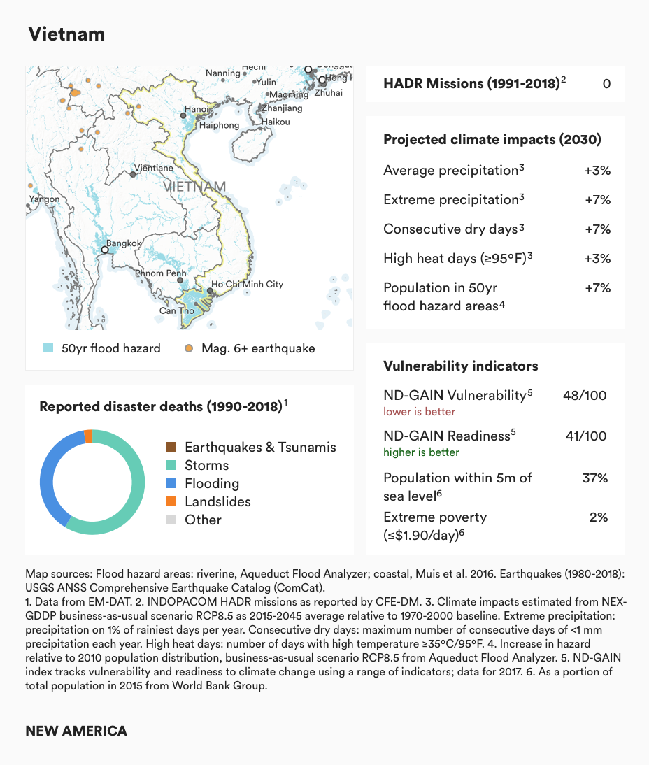
Forming the eastern flank of mainland Southeast Asia, Vietnam’s extensive coastal population is highly exposed to natural hazards. Over one-third of its population lives within 15 feet of sea level, in the path of tropical cyclones and potential tsunamis. River flooding is also a major hazard, in particular for the Red River delta in the north and the Mekong River delta in the south. Nonetheless, Vietnam has had fewer reported disaster-related deaths than many other countries in the region.
The combination of coastal population, flooding, and tropical cyclones makes Vietnam one of the countries most exposed to climate change. Though absolute precipitation may not change much within Vietnam, flood risk is likely to increase with large upstream river basins. Sea level rise will put pressure on coastal populations while increasing exposure to storm surge. Drought, extreme heat, and heavy precipitation may also increase in frequency. On the other hand, Vietnam is rapidly developing, and ranks higher on a range of development indicators than many of its neighbors.
There has not been a U.S. humanitarian and disaster relief mission in Vietnam over the past 30 years. Nonetheless, managing the impacts and increased natural hazards from climate change will be a significant challenge for the country.
Small Island States
Nowhere is climate change more of an existential threat than for the small island states of the Pacific. There are 12 small island states within Indo-Pacific Command’s area of responsibility, including Fiji, Kiribati, the Marshall Islands, Micronesia, Nauru, Palau, Samoa, the Solomon Islands, Tonga, Tuvalu, and Vanuatu, as well as the Maldives in the Indian Ocean. Their majority coastal populations are inherently exposed to tsunamis, and support systems can quickly become overwhelmed in disaster absent external support. Islands in northern and western Micronesia, including the U.S. territories of Guam and the Northern Mariana Islands, as well as those in southern Polynesia, such as Fiji and Vanuatu, also experience frequent tropical cyclones.
The most direct climate impacts for small island states will be sea level rise. Coral atolls and reef islands such as Tuvalu and the Maldives may become completely uninhabitable by the end of the century, absent large-scale sea wall engineering. Even for volcanic mounts that rise several hundred feet above sea level, coastal erosion and rising groundwater salinity may still be significant issues. Changes in weather patterns may pose a risk for islands that rely primarily on rainwater for their water supplies. Die-offs of the majority of coral reefs, which are likely with just 1.5–2ºC of warming, will reduce food security from reef fisheries, limit tourism income, and restrict natural shoreline protection. In short, climate change is a slow-moving disaster for these countries.
Although their total population is small relative to that of their mainland neighbors, over 2.5 million people live in these countries, many of whom will become climate refugees in the coming decades.
Climate Change and U.S. Military Bases in the Indo-Pacific
The United States has a significant military presence in the Indo-Pacific region, which includes a number of fixed or permanent installations. There are large U.S. bases in South Korea and Japan, but also smaller, strategically significant positions elsewhere. All are exposed to the region’s natural hazards. In March of 2011, for example, the earthquake, tsunami, and meltdown of the Fukushima Daiichi nuclear generating station caused significant damage and loss of life. There were 85 U.S. military facilities in Japan spread across 77,000 acres at the time, with 86,000 personnel and dependents (and 11,000 more personnel at sea off the coast).61 While there were no public reports of damage to U.S. bases, around 10,000 dependents voluntarily evacuated and hundreds of U.S. military personnel have alleged long-term health effects from radiation exposure.62 Of course, U.S. forces were also well placed to assist with humanitarian and disaster relief in the immediate aftermath.
An even bigger challenge may be the bases on small islands or atolls, such as Diego Garcia, Guam, and the Marshall Islands. The Department of Defense has studied the vulnerability of such locations and found cause for concern. Kwajalein Atoll in The Marshall Islands, for example, is part of the Ronald Reagan Ballistic Missile Test Site, just now receiving a billion-dollar improved radar ground station.63 According to the Defense Department’s own analysis, however, sea level rise with tidal flooding will render groundwater on the island non-potable as soon as 2035, depending on greenhouse gas emissions levels and when certain tipping points occur.64 Guam and Diego Garcia, bases that are already important to ongoing military operations and possibly even more important to future regional strategies and plans, are also vulnerable to sea level rise and tidal flooding. The Government Accountability Office found in June 2019 that the Department of Defense has neither studied the exposure of bases to natural hazards (including sea level rise and extreme weather) sufficiently, nor incorporated climate change projections into base management in consistent and significant ways.65
Other Megacities
In addition to major cities in the high-risk countries profiled above, several other cities stand out due to their outsize economic influence, large populations, and natural hazards. These include Japan’s major urban centers, Tokyo and Osaka, as well as China’s Pearl River Delta cities of Guangzhou, Shenzhen, and Hong Kong; Shanghai; and Taipei.
Japan’s major cities are exceptionally exposed to the full range of disaster risks, including major earthquakes, tsunamis, tropical cyclones, and river flooding. A 2015 study by Swiss Re rated the metropolitan areas of Tokyo, Osaka, and Nagoya, respectively, as the first, fourth, and sixth most disaster-prone cities globally.66 At the same time, Japan is often looked to as a leader in disaster management, with sophisticated early warning systems, disaster management plans, and public awareness campaigns, including a national Disaster Prevention Day commemorating the 1923 Tokyo earthquake.
China has the most megacities in the world, though the majority of its disaster-prone cities are located on the south-east coast. China’s Pearl River Delta cities also have significant global economic importance, including the commercial center of Hong Kong and the technology manufacturing hub of Shenzhen. Although these cities are not exposed to earthquakes and have low exposure to tsunamis, both tropical cyclones and river flooding pose significant risks to the delta. Swiss Re ranked the Pearl River Delta cities as a group third after Tokyo and Manila for risk exposure. The next most disaster-prone city in China, Shanghai, is primarily exposed to flooding from the Yangtze River and tropical cyclones. Taipei, on the island of Taiwan, does not qualify as a megacity with a metropolitan population of about 2.7 million. Nonetheless, Taipei rivals regional megacities in potential disaster losses due to its high earthquake risk, frequent tropical cyclones, and economic productivity. Taipei ranks fourth globally in GDP at risk after Tokyo, New York, and Manila on Lloyd’s City Risk Index.67
Citations
- UN ESCAP, “Asia-Pacific Disaster Report 2019: The Disaster Riskscape Across Asia-Pacific” (United Nations, 2019), source
- Authors’ analysis of EM-DAT disaster database. Université catholique de Louvain (UCL), CRED, and D Guha-Sapphir, “EM-DAT: The Emergency Events Database,” accessed February 23, 2019, source
- NOAA, “Japan Tsunami: Wave Heights – March 11, 2011,” Science On a Sphere, accessed March 25, 2020, source
- Nobuhito Mori et al., “Survey of 2011 Tohoku Earthquake Tsunami Inundation and Run-Up,” Geophysical Research Letters 38, no. 7 (April 1, 2011), source
- Ye Lieping et al., “Analysis on Building Seismic Damage in the Wenchuan Earthquake,” January 1, 2008.
- James Griffiths, “How Indonesia’s Tsunami Warning System Failed Its Citizens Again,” CNN, accessed March 25, 2020, source
- Hampel Andrea, Hetzel Ralf, and Maniatis Georgios, “Response of Faults to Climate-Driven Changes in Ice and Water Volumes on Earth’s Surface,” Philosophical Transactions of the Royal Society A: Mathematical, Physical and Engineering Sciences 368, no. 1919 (May 28, 2010): 2501–17, source
- Robert E. Kopp et al., “Evolving Understanding of Antarctic Ice-Sheet Physics and Ambiguity in Probabilistic Sea-Level Projections,” Earth’s Future 5, no. 12 (December 1, 2017): 1217–33, source
- T.S. Murty and R.A. Flather, “Impact of Storm Surges in the Bay of Bengal,” Journal of Coastal Research, 1994, 149–61.
- NOAA, “National Hurricane Center Forecast Verification,” April 4, 2017, source
- IPCC, 2013: Summary for Policymakers. In: Climate Change 2013: The Physical Science Basis.Contribution of Working Group I to the Fifth Assessment Report of the Intergovernmental Panel on Climate Change [Stocker, T.F., D. Qin, G.-K. Plattner, M. Tignor, S.K. Allen, J. Boschung, A. Nauels, Y. Xia, V. Bex and P.M. Midgley (eds.)]. Cambridge University Press, Cambridge, United Kingdom and New York, NY, USA. source
- Kevin J.E. Walsh et al., “Tropical Cyclones and Climate Change,” Wiley Interdisciplinary Reviews: Climate Change 7, no. 1 (January 1, 2016): 65–89, source
- James P. Kossin, Kerry A. Emanuel, and Suzana J. Camargo, “Past and Projected Changes in Western North Pacific Tropical Cyclone Exposure,” Journal of Climate 29, no. 16 (May 19, 2016): 5725–39, source
- Kevin E. Trenberth et al., “Hurricane Harvey Links to Ocean Heat Content and Climate Change Adaptation,” Earth’s Future 6, no. 5 (May 1, 2018): 730–44, source
- Winsemius, H., Ward, P., Luo, T. 2015. 'Aqueduct Global Flood Risk Maps.' Washington, DC: World Resources Institute. Available online at: source; H. C. Winsemius et al., “A Framework for Global River Flood Risk Assessments,” Hydrol. Earth Syst. Sci. 17, no. 5 (May 21, 2013): 1871–92, source; Philip J Ward et al., “Assessing Flood Risk at the Global Scale: Model Setup, Results, and Sensitivity,” Environmental Research Letters 8, no. 4 (October 28, 2013): 044019, source
- Trenberth et al., “Hurricane Harvey Links to Ocean Heat Content and Climate Change Adaptation.”
- World Bank, “Assessing Drought Hazard and Risk” (Washington, DC: International Bank for Reconstruction and Development / The World Bank, 2019).
- Asian Development Bank, “A Region at Risk: The Human Dimensions of Climate Change in Asia and the Pacific” (Manila, Philippines: Asian Development Bank, 2017), source
- Tom Gleeson et al., “Water Balance of Global Aquifers Revealed by Groundwater Footprint,” Nature 488, no. 7410 (August 1, 2012): 197–200, source
- Shakoor Hajat and Tom Kosatky, “Heat-Related Mortality: A Review and Exploration of Heterogeneity.,” Journal of Epidemiology and Community Health 64, no. 9 (September 2010): 753–60, source
- See e.g. Xiaoxu Wu et al., “Impact of Climate Change on Human Infectious Diseases: Empirical Evidence and Human Adaptation,” Environment International 86 (January 1, 2016): 14–23, source; National Research Council (US) Committee on Climate, Ecosystems, Infectious Diseases, and Human Health, “Climate Influences on Specific Diseases,” in Under the Weather: Climate, Ecosystems, and Infectious Disease. (Washington, DC: National Academies Press (US), 2001), source
- Marc Lipsitch, “Seasonality of SARS-CoV-2: Will COVID-19 Go Away on Its Own in Warmer Weather?,” Center for Communicable Disease Dynamics (blog), February 26, 2020, source
- T. Matthews, R. L. Wilby, and C. Murphy, “An Emerging Tropical Cyclone–Deadly Heat Compound Hazard,” Nature Climate Change 9, no. 8 (August 1, 2019): 602–6, source
- Toph Allen et al., “Global Hotspots and Correlates of Emerging Zoonotic Diseases,” Nature Communications 8, no. 1 (October 24, 2017): 1–10, source
- Thomas Stanley and Dalia B. Kirschbaum, “A Heuristic Approach to Global Landslide Susceptibility Mapping,” Natural Hazards 87, no. 1 (May 1, 2017): 145–64, source
- NSIDC, “Glaciers and Climate Change,” National Snow and Ice Data Center, March 16, 2020, source
- David R. Rounce, C. Scott Watson, and Daene C. McKinney, “Identification of Hazard and Risk for Glacial Lakes in the Nepal Himalaya Using Satellite Imagery from 2000–2015,” Remote Sensing 9, no. 7 (July 2017): 654, source
- Current rates of global warming and their impacts are gradual from a human perspective, with most indicators projected to change less than a percentage point per year. However, from a geological perspective, current changes to the Earth are an order of magnitude faster than they have ever been over 65 million years. Richard E. Zeebe, Andy Ridgwell, and James C. Zachos, “Anthropogenic Carbon Release Rate Unprecedented during the Past 66 Million Years,” Nature Geoscience 9, no. 4 (April 2016): 325–29, source
- RCP stands for Representative Concentration Pathway. Cubasch, U., D. Wuebbles, D. Chen, M.C. Facchini, D. Frame, N. Mahowald, and J.-G. Winther, 2013: Introduction. In: Climate Change 2013: The Physical Science Basis. Contribution of Working Group I to the Fifth Assessment Report of the Intergovernmental Panel on Climate Change [Stocker, T.F., D. Qin, G.-K. Plattner, M. Tignor, S.K. Allen, J. Boschung, A. Nauels, Y. Xia, V. Bex and P.M. Midgley (eds.)]. Cambridge University Press, Cambridge, United Kingdom and New York, NY, USA.
- Ross J. Salawitch et al., Paris Climate Agreement: Beacon of Hope, Springer Climate (Springer International Publishing, 2017), source
- IPCC, 2007: Summary for Policymakers. In: Climate Change 2007: The Physical Science Basis. Contribution of Working Group I to the Fourth Assessment Report of the Intergovernmental Panel on Climate Change [Solomon, S., D. Qin, M. Manning, Z. Chen, M. Marquis, K.B. Averyt, M.Tignor and H.L. Miller (eds.)]. Cambridge University Press, Cambridge, United Kingdom and New York, NY, USA. source
- F. S. Syed et al., “Uncertainties in the Regional Climate Models Simulations of South-Asian Summer Monsoon and Climate Change,” Climate Dynamics 42, no. 7 (April 1, 2014): 2079–97, source
- For a comprehensive overview of climate impacts on the Indo-Pacific region, see: Asian Development Bank, “A Region at Risk: The Human Dimensions of Climate Change in Asia and the Pacific.” source
- Robert E. Kopp et al., “Evolving Understanding of Antarctic Ice-Sheet Physics and Ambiguity in Probabilistic Sea-Level Projections,” Earth’s Future 5, no. 12 (December 1, 2017): 1217–33, source
- Cynthia Rosenzweig et al., “Assessing Agricultural Risks of Climate Change in the 21st Century in a Global Gridded Crop Model Intercomparison,” Proceedings of the National Academy of Sciences 111, no. 9 (March 4, 2014): 3268, source
- K. Frieler et al., “Limiting Global Warming to 2 °C Is Unlikely to Save Most Coral Reefs,” Nature Climate Change 3, no. 2 (February 1, 2013): 165–70, source
- M.T.H. van Vliet et al., “Multi-Model Assessment of Global Hydropower and Cooling Water Discharge Potential under Climate Change,” Global Environmental Change 40 (September 1, 2016): 156–70, source
- Petra Low, “The Natural Disasters of 2018 in Figures,” Munich Re (blog), January 8, 2019, source
- United Nations. 2018. World Urbanization Prospects: the 2018 Revision. source
- Y. Adikari, R. Osti, and T. Noro, “Flood-Related Disaster Vulnerability: An Impending Crisis of Megacities in Asia,” Journal of Flood Risk Management 3, no. 3 (2010): 185–91, source
- Charles R. Smith, Angels from the Sea: Relief Operations in Bangladesh, 1991 (Washington, DC: History and Museums Division Headquarters, U.S. Marine Corps, 1995), 1,8. Richard L. Berke, "US Sends Troops to Aid Bangladesh in Cyclone Relief," New York Times, May 12, 1991.
- Charles R. Smith, Angels from the Sea: Relief Operations in Bangladesh, 1991 (Washington, DC: History and Museums Division Headquarters, U.S. Marine Corps, 1995), 41.
- Smith, 19.
- Smith, 36.
- Paul McCarthy, Operation Sea Angel A Case Study (Santa Monica, CA: RAND, 1994), 15.
- Charles R. Smith, Angels from the Sea: Relief Operations in Bangladesh, 1991 (Washington, DC: History and Museums Division Headquarters, U.S. Marine Corps, 1995), 76.
- Charles R. Smith, Angels from the Sea: Relief Operations in Bangladesh, 1991 (Washington, DC: History and Museums Division Headquarters, U.S. Marine Corps, 1995), 48.
- “World Development Indicators.” World Development Indicators (WDI) | Data Catalog. World Bank, March 18, 2020. source
- World Bank, “World Development Indicators.”
- Richard Harris. "Why Typhoon Haiyan Caused So Much Damage?" NPR, November 11, 2013, source
- National Oceanic and Atmospheric Administration, “Hurricane Michael Upgraded to a Category Five at Time of U.S. Landfall,” April 19, 2019.
- "Case Study: Typhoon Haiyan," BBC, source
- Thomas Lum and Rhoda Margesson, Typhoon Haiyan (Yolanda): U.S. and International Response to Philippines Disaster (Washington, DC: Congressional Research Service, 2014).
- Barbara Salazar Torreon and Sofia Plagakis, Instances of Use of United States Armed Forces Abroad, 1798-2018 (Washington, DC: Congressional Research Service, 2018): 30.
- Thomas Lum and Rhoda Margesson, Typhoon Haiyan (Yolanda): US and International Response to Philippines Disaster (Washington, DC: Congressional Research Service, 2014): 8.
- The White House Office of the Press Secretary, Fact sheet: U.S. Response to Typhoon Haiyan, Nov 19, 2013.
- The White House Office of the Press Secretary, Fact sheet: U.S. Response to Typhoon Haiyan.
- Thomas Parker, Sean P. Carrol, Gregg Sanders, Jason King and Imes Chiu, "The U.S. Pacific Command Response to Super Typhoon Haiyan," Joint Force Quarterly 82 (July 1, 2016): 55.
- "Typhoon Haiyan: U.S. carrier boosts Philippines relief effort," BBC, November 14, 2013.
- "Typhoon Haiyan: Japan's biggest overseas military deployment since WWII arrives in Philippines," Straits Times, November 22, 2013.
- Andrew Feikert and Emma Chanlett-Avery, Japan 2011 Earthquake: U.S. Department of Defense Response (Washington, DC: Congressional Research Service, June 2, 2011). source
- Kristina Davis, “San Diego Judge Dismisses U.S. Sailors’ Fukushima Radiation Lawsuits, Rules Japan Has Jurisdiction,” The San Diego Union Tribune, March 5, 2019, source
- Nathan Strout, “A New Radar to Track Space Objects is Almost Ready,” C4ISRNET, December 11, 2019. source
- Curt Storlazzi, The Impact of Sea-Level Rise and Climate Change on Department of Defense Installations on Atolls in the Pacific Ocean (Washington, DC: Department of Defense Strategic Environmental Research and Development Program, August 31, 2017), source
- Diana Maurer, Climate Resilience: DoD Needs to Assess Risk and Provide Guidance on Use of Climate Projections in Installation Master Plans and Facilities Designs (Washington, DC: U.S. Government Accountability Office, GAO-19-453, June 2019). source
- “Mind the risk: cities under threat from natural disasters” Swiss Re Institute, 2015, source
- “Lloyd’s City Risk Index,” University of Cambridge Centre for Risk Studies, 2018, source