
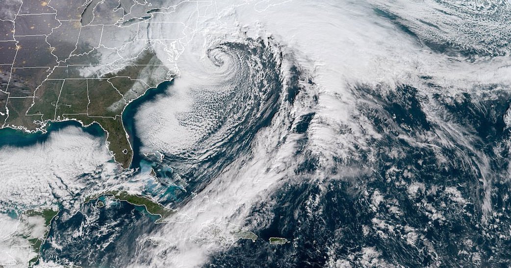
The last week of January 2019 will be a cold one across the northeastern half of the United States, with temperatures plunging as low as -46 degrees in Chicago and -49 degrees in Minneapolis. Or as the National Weather Service says on the banner at the top of its site: “very dangerous and life-threatening Arctic air mass expected this week.”
In other words, the polar vortex strikes again.
But just what is a polar vortex? Is it a new kind of weather? Why did we only start hearing about it in the last few years?
The term Polar Vortex is commonly used as shorthand for circumpolar vortex, a “planetary-scale westerly flow that encircles the pole in middle or high latitudes.” Although the polar vortex was mentioned as early as 1853, it wasn’t until the 1950s that scientists really began to study this phenomenon. Both the South Pole and the North Pole have vortices, and there are actually two kinds (stratospheric and tropospheric) as seen in the graphic below. These vortices are a fundamental feature of Earth’s climatology and are always there (in fact, they also exist on other planets).
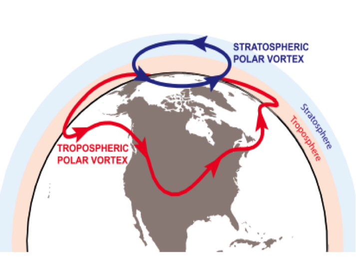
Basically, a circumpolar vortex is an immense whirlpool of cold air centered over the Arctic. The tropospheric (i.e., the lowest part of the Earth’s atmosphere, closest to the surface) vortex exists all year and is much larger than its stratospheric cousin, playing a more important role for surface weather at midlatitudes (which includes the United States, Europe, Central Asia, and East Asia). The stratospheric polar vortex higher up in the atmosphere forms in the fall when there is little to no solar heating in polar regions, becomes stronger during the winter, then breaks down as sunlight reaches the poles in the spring. The boundary of the stratospheric polar vortex—the polar front jet stream, a narrow band of very fast moving air traveling west to east, which can also sometimes move north and south—is between the colder polar air in the north and the warmer subtropical air. This boundary shifts all of the time, shrinks in the summer, and in the winter it dips down to the south.
While the Polar Vortex is not a new phenomenon, there is some debate about whether these chilly winds are moving farther and occurring more frequently than in the past. The degree to which climate change in particular influences midlatitude weather through the weakening of the polar front jet stream or the midlatitude jet stream is an esoteric but lively academic debate. The climate is changing — that’s not part of the debate — and Arctic sea ice is definitely melting, as satellite imagery shows, but drawing causal linkages between, say, sea-ice loss and the North-South variability of either of the the jet streams is tough. Likewise, it is difficult to draw causal linkages for the inverse, or the extent to which midlatitude circulation affects surface air temperature in the Arctic. Partly due to the fact that different mathematical models based on weather data produce conflicting results (be they due to differences in observational analysis or experimental design), but also in part due to the fact that Earth’s climate system is complex, highly variable, and undergoing constant, simultaneous changes.
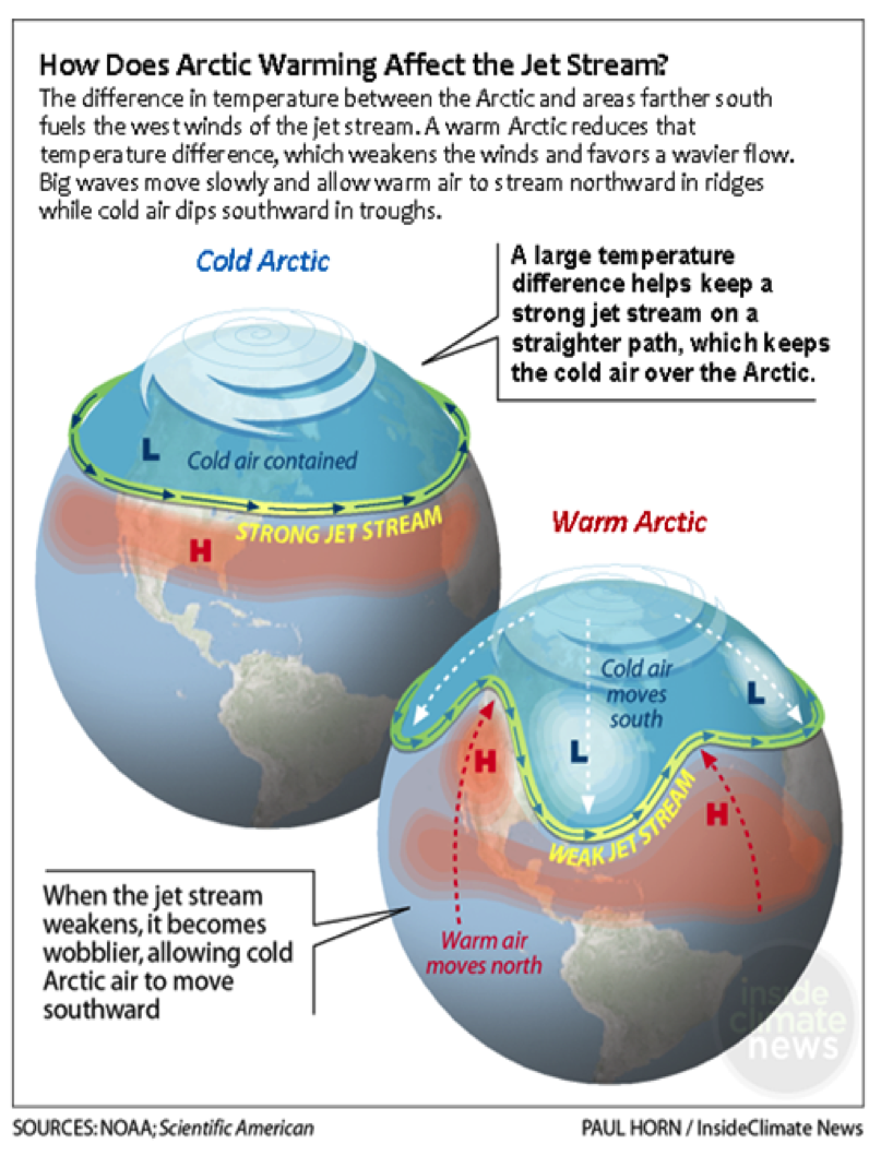
The Arctic warms at a faster rate relative to the rest of the northern hemisphere, which scientists refer to as Arctic amplification or Amplified Arctic Warming (AAW). As the Arctic warms, the temperature differential between the Arctic and the midlatitudes shrinks. This connects to sea-ice loss: less ice means more open water, which absorbs solar radiation, unlike the ice, which reflects it. The overall effect is to reduce Earth’s albedo—the ratio of incoming solar radiation reflected by the surface of a celestial object back into the atmosphere and space. A lower albedo means warmer surface temperatures, a loop that also means more melting of sea ice.
Earth’s climate system is exactly that — a system, making the isolation of any one variable’s effects on that system incredibly difficult. To try to understand such effects, scientists use a variety of modeling techniques. For example, one source of the current debate is that some scientists use only sea-ice loss as a proxy for AAW in forcing an atmospheric response. This can lead to confusion because sea-ice loss accounts for “only a fraction of AAW.” Put another way, while sea-ice loss contributes to AAW, a number of other variables also bring about AAW. Observational analysis can be helpful, but scientists note that research utilizing remote sensing technology to make observations can only use the available data, which does not yet reach far back enough in time to allow researchers to distinguish between natural variability in the jet streams (up to 10 degrees latitude from year to year) and forced variability due to AAW. Recently, research concerning the atmospheric response to AAW is gaining traction, as is the conversation regarding the general relationship between AAW and natural variability in Earth’s climate system. Models are improving all the time, but there is so much more research to be done.
The truth is, it's complicated, and scientists are likely a long way away from reaching anything resembling consensus. In other words, “while there is a growing consensus in the model-based literature that Arctic warming can, in isolation [italics added], significantly influence the midlatitude circulation, this neither implies that is has in the past, nor that it will in the future.” So, while there is still not a great deal of clarity about whether the Polar Vortex is changing because of climate change, one thing is very clear: it’s going to be very cold outside this week. Bundle up!
More About the Authors
Related
Climate Security: Building a Community of Practice
Climate Change, Peace and Security, and the UN Group of Friends
Infrequently Asked Questions