Creating a Shared Visual Language for Mesh Wireless Technology
Blog Post
Jan. 20, 2012
A compelling picture is definitely worth the proverbial thousand words for explaining new kinds of wireless networks – especially when that picture appears alongside comprehensible technical information. And yet our choices about visual and written language say a lot about just who we expect to participate in building, using and maintaining networks. Complex diagrams run the risk of confusing audiences of potential community network participants, especially if graphics are abstract or surrounded by technical details and jargon.
In order to better reflect our principles of accessibility, participation and common ownership, OTI has worked over the last year to evolve the way we depict communications infrastructure and build-out processes, both visually and technically.
Understanding the Social Network
An initial community wireless pilot project in the North Corktown neighborhood of Detroit demonstrated the clear importance of strong social networks for the construction of new open wireless networks. Moreover, we saw that if we want wireless technology to benefit communities who are currently excluded from the Internet and digital communications, we have to draw on a neighborhood's social cohesion – the connections among its people and relationships – and not necessarily its current technological know-how.
Starting from this premise, we thought that the far southwest section of Detroit, known locally as “48217” after its zip code, seemed well-positioned to take advantage of mesh wireless technology. There were almost as many community leaders from 48217 as from all other Detroit organizations combined at a 2010 meeting convened by the Detroit Digital Justice Coalition for recipients of federal funds for public computer centers. 48217 is home to a robust and close-knit network of neighborhood organizations, or block clubs. We imagined that block captains could first connect to each other using wireless routers to form a basic rooftop network, then other members of the block club could connect to the captains by placing routers in their windows.
We also proposed that a few key institutions (libraries, churches, schools, etc., which are generally taller structures) could potentially anchor the network by installing high-power routers to transmit over lines-of-sight to tall points in other parts of the city. However, four of the neighborhood’s five schools have closed, the nearest branch of the public library is a 45-minute bus ride away, and the Rouge River, Interstate-75 and heavy industry impose severe geographic barriers. 48217 does have churches and a few secular institutions that serve as community centers, including the Kemeny Recreation Center and The Rollercade, a neighborhood roller skating rink. Using these buildings, residents could connect across major thoroughfares and other divisions within 48217 and potentially beyond, reducing their geographic isolation. And they could use just a handful of Internet connections, distributed through the local wireless network, to connect to the rest of the world.
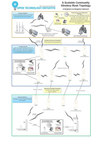
In order to illustrate this three-tier network topology – an initial network installed on block captains’ roofs, network infill via routers in neighbors’ windows, and citywide links via anchor institutions – former OTI Technologist Dan Meredith and I drew a diagram. We tried to show a network where anyone could offer applications or services, including but not limited to Internet access. We put the residents’ “network tier” at the top of the diagram to convey that it was our priority, and tried to describe an inclusive system of network management, not one managed by any single institution. We tried to avoid specifying hardware or software requirements, since we felt decisions about equipment should be made by the neighborhood residents who would be using and maintaining the network.
In the end, though, it would be hard for someone who was new to Wi-Fi or mesh to look at the diagram we made and see their own experience in it. The picture told a story of a complex technology abstracting – not reinforcing – existing neighborhood relationships.
Collaborative Design of Outreach Materials
Our next step in 48217 was to meet up with neighborhood residents and present our ideas to them. In order to assess the feasibility of a wireless network, Rhonda Anderson of the Detroit Sierra Club and I met with Dr. Dolores Leonard, a retired Wayne County Community College professor who maintains a youth-oriented “Reading Corner” at the Kemeny Recreation Center. Rhonda and I were representing the Detroit Digital Justice Coalition (DDJC), which had just helped The Reading Corner secure four new computer workstations through a Broadband Technology Opportunities Program grant administered by Michigan State University.
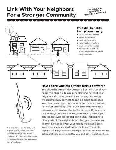
We sat in Dr. Leonard’s living room for nearly two hours while she led us through a Socratic investigation of the proposed network concept. She knew what questions to ask in order to identify the aspects of the plan would most inspire her neighbors to participate or cause them concern. She began naming people in the neighborhood who she thought would be willing to take part in the project by sharing an Internet connection or hosting a wireless router to repeat a signal. Finally, Dr. Leonard asked us to create a flyer that she could use to explain the project to her neighbors, detailing was being asked of people and what was being offered, the expected costs and the potential benefits.
On the one hand, this was the best possible outcome: a trusted community leader would be leading the outreach effort. On the other hand, it meant she would need to have all of the necessary information to explain the project to her neighbors in a comprehensible form. We asked Nina Bianchi, a graphic designer with the DDJC, to lead the production of the flyer.
We started with some design parameters: the flyer had to be 8.5”x11” and black and white for easy printing and copying. It could not rely on a reference to a website for more information, since the intended audience included people without access to the Internet. All fonts had to be at least 13-point to make the text readable for seniors. And the visuals and words had to be readily understandable or explained on the flyer itself. To achieve the last goal, we went through several iterations with Rhonda, Dr. Leonard, and other community members. Any word or shape that caused confusion we replaced, revised, removed or explained.
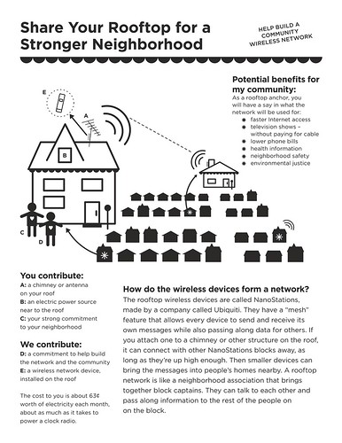
Corresponding to the intended network tiers, the first flyer was for community leaders to conduct outreach with block captains by explaining what was needed for a rooftop mesh network. The second would be for the captains to use on their blocks in order to explain the project to their neighbors.
Producing a Graphical Lexicon
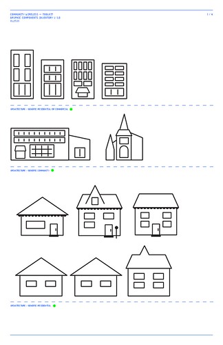
Nina’s innovative approach with these flyers was to develop not only an accessible style and clear narrative, but also to produce modular graphical elements that she could rearrange following input from 48217 community organizers and OTI technologists. Each flyer held a coherent statement, while together their graphic elements started to create a visual lexicon for mesh wireless technology.
Over the course of the year, we added new graphic elements to the collection to fit other situations. As we investigated wireless networking opportunities in Philadelphia, we found that we needed elements to represent churches and community centers. In order to help the protesters at McPherson Square in DC achieve connectivity, we needed to show them a network that included office buildings. In each case, Nina reused as many of the existing elements as possible, adding the minimum number of new ones. Finally she produced an initial library of all the modular graphics, grouped thematically and packaged as a PDF.
When OTI chose to respond to a request for information from Gig.U we had a chance to test out the idea that one could reassemble the elements included in the 48217 flyers – plus a few additions – to tell a different story. Gig.U was seeking ideas on how to best use hybrid wireless / wired networks to connect universities and their surrounding communities. We wanted to present the same technical overview we had hoped to convey in our initial diagram. OTI Policy Analyst Greta Byrum was able to import the individual graphic elements into a vector drawing program, combine them with the language from the initial diagram, and produce a diagram that conveyed an engineering plan and a narrative.

From a technical standpoint, the diagram for Gig.U described a similar three-tiered network as the initial diagram that Dan and I had created – with the key difference that Gig.U was looking for hybrid wireless-fiber designs. Greta added the multicolored lines to depict the fiber ring. For a separate diagram, she used some of the same elements at a different scale to present a closeup of the wireless component.

The key difference is that the updated version better reflects the participatory design principles we discussed in our response. We argued that a network built with the engagement of neighborhood residents would be more successful at connecting the entire community than a network with a design focus purely on the technical requirements at the expense of the social ones. The proposed process would only be possible with a common shared visual and technical language for the university, the network engineers, and the local residents to discuss and plan stages of collaborative network build-out. Even if we used some specialized language to offer precision to the engineers, the pictures tell the story of a neighborhood with its varied institutions united by wire-line and wireless connections.
In partnership with Nina and her company, The Work Department, and thanks to support from the Knight Foundation, we are planning to release an initial version of our graphical lexicon in the coming weeks. We plan to continue developing it with contributions from other designers, planners, organizers, technicians and educators. Because infrastructure systems are complex and interdependent, we need to design communications infrastructure in coordination with systems for transportation, energy, food and waste. This requires a participatory design platform versatile enough to work for multiple scenarios and urban typologies.
Our initial success with the beta version of this design platform has been primarily in the visual realm, but we face a comparable need for comprehensibility in our verbal materials. To this end, Nina and I recently experimented with a mini-workshop that restricted people to describing a technology using only basic shapes and half of an English-as-a-second-language vocabulary list I found online.
The text from these experiments and from the initial 48217 flyers is a start in developing comprehensible language to describe new technologies – but at the ratio of a thousand words to every picture, we have our work cut out for us.